I ask that all the lands in and around Rathcoole Woodlands that are re-wilding be protected. Survey Reports (BSM report, and Hodd report) have shown not only that these contain rare EU protected...
Chapter 2: Core Strategy and Settlement Strategy
Closed29 Mar, 2022, 00:00 - 26 Apr, 2022, 23:59
Following are the proposed material amendments to Chapter 2. Please note Amendment 2.1 relates to a number of sections of Chapter 2 relating to alignment of figures with the 6-year life of the plan and will be considered as one amendment.
| Chapter/ Section | Section 2.2 Executive Summary |
| Amendment ref. | Amendment 2.1 |
| Page no. |
28 |
| Policy/Objective No. | Text Change - 2.2 Executive Summary |
| Consequential Amendment |
Consequential Amendment arising from Material Amendment 2.1 |
| Text/Policy/Objective Amendment Wording | |
|
Amend text from: Taking account of completed units between 2017 and 2021 (5,914 Units) there is an overall requirement of 17,817 units between 2021 and 2028. The Core Strategy (Table 10) demonstrates how this target can be met up to 2028 taking into consideration units under construction. It has been developed by applying a four-step approach to the identification and assessment of lands capable of meeting this housing requirement. To Read:
Taking account of completed units between 2017 and Q3 2021 |
|
| Chapter/ Section | Section 2.2 Executive Summary |
| Amendment ref. | Amendment 2.1 |
| Page no. |
29 |
| Policy/Objective No. | Text Change - 2.2 Executive Summary |
| Consequential Amendment |
Consequential Amendment arising from Material Amendment 2.1 View Consequential Amendments [PDF] |
| Text/Policy/Objective Amendment Wording | |
|
Amend text from:
To Read:
|
|
| Chapter/ Section | Table 7 - Section 2.5.5 Housing Supply Targets | ||||||||||||||||||||||||||||||||||||||||
| Amendment ref. | Amendment 2.1 | ||||||||||||||||||||||||||||||||||||||||
| Page no. |
43 |
||||||||||||||||||||||||||||||||||||||||
| Policy/Objective No. | Update Table 7: South Dublin Housing Demand Figures 2021 – 2028 - 2.5.5 Housing Supply Targets | ||||||||||||||||||||||||||||||||||||||||
| Consequential Amendment |
Consequential Amendment arising from Material Amendment 2.1 View Consequential Amendments [PDF] |
||||||||||||||||||||||||||||||||||||||||
| Text/Policy/Objective Amendment Wording | |||||||||||||||||||||||||||||||||||||||||
|
Amend Table 7 from: Table 7: South Dublin Housing Demand Figures 2021 – 2028
To read:
Table 7: South Dublin Housing Demand Figures
*Methodology based on Housing Supply Guidelines issued by Department of Housing, Local Government and Heritage |
|||||||||||||||||||||||||||||||||||||||||
| Chapter/ Section | Table 9 - Section 2.6.1 Land Capacity Study |
| Amendment ref. | Amendment 2.1 |
| Page no. |
49 |
| Policy/Objective No. |
Update Table 9: Capacity of undeveloped lands within South Dublin - 2.6.1 Land Capacity Study |
| Consequential Amendment |
Consequential Amendment arising from Material Amendment 2.1 View Consequential Amendments [PDF] |
| Text/Policy/Objective Amendment Wording | |
|
Amend Table 9 from: Table 9: Capacity of undeveloped lands within South Dublin To read: Table 9: Capacity of Undeveloped Lands within South Dublin 2022-2028 (Scroll the tables horizontally to view all colums using the scrollbar under each table) |
|
Table 9: Capacity of undeveloped lands within South Dublin
|
Settlement Type |
Settlement Name |
Residential (HA) |
Residential (Units) |
Mixed-Use (HA) |
Mixed-Use (Units) |
Total Potential (HA) |
Total Potential (Units) |
||||
|
Dublin City and Suburbs |
Tallaght |
22.5 |
0 |
661 |
0 |
0 |
28.13 |
0 |
2,902 |
50.7 |
3,563 |
|
Naas Road |
0 |
0 |
0 |
0 |
0 |
21.73 |
0 |
1,123 |
21.73 |
1,123 |
|
|
Templegoue, Walkinstown, Rathfarnham, Firhouse |
97.02 |
0 |
4,222 |
0 |
0 |
11.88 |
0 |
890 |
108.9 |
5,112 |
|
|
Clondalkin, Clonburris and Grange Castle |
4.05 |
10.84 |
286 |
798 |
73.31 |
17.62 |
2,744 |
1,355 |
105.82 |
5,183 |
|
|
Lucan, Adamstown, Palmerstown |
5.92 |
0.36 |
464 |
20 |
52.6 |
16.93 |
1,748 |
1,226 |
75.81 |
3,458 |
|
|
Citywest |
45.94 |
2.64 |
2,604 |
159 |
2.45 |
2.25 |
245 |
135 |
53.28 |
3,143 |
|
|
Sub-total of Dublin City and Suburbs |
175.5 |
13.84 |
8,237 |
977 |
128.36 |
98.54 |
4,737 |
7,631 |
416.2 |
21,582 |
|
|
Self-Sustaining Town |
Saggart |
5.77 |
0.27 |
202 |
10 |
0 |
1.13 |
0 |
39 |
7.17 |
251 |
|
Self-Sustaining Growth Towns |
Newcastle |
22.79 |
1.42 |
797 |
50 |
0 |
1.12 |
0 |
39 |
25.33 |
886 |
|
Rathcoole |
24.47 |
1.13 |
820 |
39 |
1.94 |
0 |
0 |
68 |
27.54 |
927 |
|
|
Sub-total of Towns |
53.03 |
2.82 |
1,819 |
99 |
1.94 |
2.25 |
0 |
146 |
60.04 |
2064 |
|
|
Sub-total of urban area |
228.5 |
16.66 |
10,056 |
1,076 |
130.3 |
100.7 |
4,737 |
7,777 |
477 |
23,730 |
|
|
Combined Totals |
245 |
11,132 |
231 |
12,514 |
|
|
|||||
|
A – Total Capacity South County Dublin |
|
477 |
23,730 |
||||||||
|
B - Housing Need for South Dublin (2017 – Q3 2028) |
- |
- |
- |
23,731 |
|||||||
|
C - Completed Units (2017 – 2021) |
- |
- |
- |
5,914 |
|||||||
|
D – Housing Need for South Dublin (2021 – 2028) (B minus C) |
- |
- |
- |
17,817 |
|||||||
|
E - Units under construction (Estimated from Feb 2021) |
- |
- |
- |
4,557 |
|||||||
|
F - Net Housing Need for South Dublin (2021 – 2028) (D minus E) |
- |
- |
- |
13,260 |
|||||||
|
G – Surplus (A minus F) across Tier 1 and Tier 2 |
- |
- |
- |
10,470 |
|||||||
Table 9: Capacity of Undeveloped Lands within South Dublin 2022-2028
|
Settlement Type |
Settlement Name |
Residential (HA) |
Residential (Units) |
Mixed-Use (HA) |
Mixed-Use (Units) |
Total Potential (HA) |
Total Potential (Units) |
||||
|
Dublin City and Suburbs |
Tallaght |
22.5 |
0 |
661 |
0 |
0 |
25.43 |
0 |
2,767
|
48 |
3,428 |
|
Naas Road |
0 |
0 |
0 |
0 |
0 |
21.73 |
0 |
1,123 |
21.73 |
1,123 |
|
|
Templegoue, Walkinstown, Rathfarnham, Firhouse |
91.5 |
0 |
3,946 |
0 |
0 |
11.88 |
0 |
890 |
103.38 |
4,836 |
|
|
Clondalkin, Clonburris and Grange Castle |
4.05 |
10.84 |
286 |
798 |
70.39 |
17.62 |
2,660 |
1,355 |
101.9 |
5,099 |
|
|
Lucan, Adamstown, Palmerstown |
5.92 |
0.36 |
464 |
20 |
39.62 |
16.93 |
1,099 |
1,226 |
62.83 |
2,809 |
|
|
Citywest |
31.54 |
2.64 |
1,884 |
159 |
2.45 |
2.25 |
245 |
135 |
38.88 |
2,423 |
|
|
Sub-total of Dublin City and Suburbs |
155.51 |
13.84 |
7,241 |
977 |
112.46 |
95.84 |
4,044 |
7,496 |
377.65 |
19,718 |
|
|
|
|
|
|
|
|
|
|
|
|
|
|
|
Self-Sustaining Growth Towns |
Newcastle |
15.94 |
1.42 |
557 |
50 |
0 |
1.12 |
0 |
39 |
18.48 |
646 |
|
Rathcoole |
21.22 |
1.13 |
699 |
39 |
1.94 |
0 |
0 |
68 |
24.29 |
806 |
|
|
Self-Sustaining Town |
Saggart |
5.77 |
0.27 |
271 |
10 |
0 |
1.13 |
0 |
39 |
7.17 |
320 |
|
|
|
|
|
|
|
|
|
|
|
|
|
|
Sub-total of Towns |
42.93 |
2.82 |
1,527 |
99 |
1.94 |
2.25 |
0 |
146 |
49.94 |
1,772 |
|
|
Sub-total of urban area |
198.44 |
16.66 |
8,768 |
1,076 |
114.4 |
98.09 |
4,004 |
7.642 |
427.59 |
21,490 |
|
|
Combined Totals |
215.1 |
9,844 |
212.49 |
11,646 |
|
|
|||||
|
A – Total Capacity South County Dublin |
|
427.59
|
21,490
|
||||||||
|
B - Housing Need for South Dublin ( |
|
|
|
21,490
|
|||||||
|
C - Completed Units (2017 – 2021) Note: Q3 2021 to Q3 2022 Completions have been incorporated into the revised figures for each area in the above table |
|
|
|
5,914
|
|||||||
|
D – Housing Need for South Dublin ( |
|
|
|
15,576
|
|||||||
|
E - Units under construction (Estimated |
|
|
|
2,438
|
|||||||
|
F - Net Housing Need for South Dublin ( |
|
|
|
13,138
|
|||||||
|
G – Additional Capacity |
|
|
|
8,352
|
|||||||
| Chapter/ Section | New Table 10 - Section 2.6.5 Core Strategy – 2022 – 2028 Development Plan |
| Amendment ref. | Amendment 2.1 |
| Page no. |
|
| Policy/Objective No. | Insert New Table 10: Capacity of additional zoned undeveloped lands within South Dublin- 2.6.5 Core Strategy – 2022 – 2028 Development Plan |
| Consequential Amendment |
Consequential Amendment arising from Material Amendment 2.1 View Consequential Amendments [PDF] |
| Text/Policy/Objective Amendment Wording | |
|
Insert New Table 10: Indicative Capacity of Additional Zoned Lands in the South Dublin County Development Plan 2022-2028
|
|
Table 10: Indicative Capacity of Additional Zoned Lands in the South Dublin County Development Plan 2022-2028
|
Settlement Type |
Settlement Name |
Additional Zoned Land |
Residential (HA) |
Residential (Units) |
Mixed-Use (HA) |
Mixed-Use (Units) |
Total Potential (HA) |
Total Potential (Units) |
||||
|
Dublin City and Suburbs |
Tallaght |
Lands at Kiltipper Road |
0.48 |
0 |
10 |
0 |
0 |
0 |
0 |
0 |
0.48 |
10 |
|
|
Whitestown Way Regen Lands |
0 |
0 |
0 |
0 |
0 |
2.82 |
0 |
190-340 |
2.82 |
190-340 |
|
|
Naas Road |
- |
0 |
0 |
0 |
0 |
0 |
0 |
0 |
0 |
0 |
|
|
|
Templegoue, Walkinstown, Rathfarnham, Firhouse |
- |
0 |
0 |
0 |
0 |
0 |
0 |
0 |
0 |
0 |
0 |
|
|
Clondalkin, Clonburris and Grange Castle |
- |
0 |
0 |
0 |
0 |
0 |
0 |
0 |
0 |
0 |
0 |
|
|
Lucan, Adamstown, Palmerstown |
Ash Park Court
|
.036 |
0 |
1 |
0 |
0 |
0 |
0 |
0 |
0.36 |
1 |
|
|
|
Cooldrinagh |
3.96 |
0 |
8 |
0 |
0 |
0 |
0 |
0 |
3.96 |
8* |
|
|
Citywest |
|
0 |
0 |
0 |
0 |
0 |
0 |
0 |
0 |
0 |
0 |
|
|
Total of Additional Zoned Land |
|
4.8 |
0 |
19 |
0 |
0 |
2.82 |
0 |
190-340 |
7.62 |
209-359 |
|
*Low density housing subject to CS11 SLO 1 – Indicative potential for 3 to 8 units (c.3 units on existing greenfield lands/ up to c.5 units on existing residential back land)
| Chapter/ Section | New Table 11 - Section 2.6.5 Core Strategy – 2022 – 2028 Development Plan |
| Amendment ref. | Amendment 2.1 |
| Page no. |
54 |
| Policy/Objective No. | Update Table 10: Core Strategy Table 2022 – 2028 - 2.6.5 Core Strategy – 2022 – 2028 Development Plan |
| Consequential Amendment |
Consequential Amendment arising from Material Amendment 2.1 View Consequential Amendments [PDF] |
| Text/Policy/Objective Amendment Wording | |
|
Amend Table 10 from: Table 10: Core Strategy Table 2022 – 2028
To Read: Table
|
|
Table 10: Core Strategy Table 2022 – 2028
|
Settlement Type |
Neighbourhood Area / Settlement Name |
2016 persons |
2016 units & share (%) |
Estimated Built 2016 to Q4 2020 and share (%) |
Total Land (HA) 2021 - 2028 |
Total Housing (Units) 2021 – 2028 and share (%) |
Total 2028 units and share (%) |
Target 2028 persons and share (%) |
Population Growth from2016 persons No. (%) |
|
Dublin City and Suburbs |
Tallaght |
71,350 |
24,080 (25%) |
700 (12%) |
42.54 |
2,000 (11%) |
26,780 (22%) |
76,525 (24%) |
+5,175 (7%) |
|
Naas Road |
1,384 |
396 (0.4%) |
15 (0%) |
20.02 |
1,010 (6%) |
1,421 (1%) |
3,349 (1%) |
+1,965 (142%) |
|
|
Templegoue, Walkinstown, Rathfarnham, Firhouse |
78,166 |
28,503 (30%) |
1,750 (30%) |
55.91 |
1,953 (11%) |
32,206 (27%) |
85,264 (26%) |
+7,098 (9%) |
|
|
Clondalkin, Clonburris and Grange Castle |
44,500 |
14,869 (16%) |
200 (3%) |
122.3 |
5,385 (30%) |
20,454 (17%) |
55,206 (17%) |
+10,706 (24%) |
|
|
Lucan, Adamstown, Palmerstown |
59,000 |
19,069 (20%) |
1,625 (28%) |
93.83 |
3,322 (19%) |
24,039 (20%) |
68,483 (21%) |
+9,483 (16%) |
|
|
Citywest |
8,238 |
2,503 (3%) |
1,164 (20%) |
78.52 |
2,833 (16%) |
6,502 (5%) |
15,900 (5%) |
+7,662 (93%) |
|
|
Sub-Total |
262,638 |
89,420 (94%) |
5,454 (93%) |
413 |
16,503 (93%) |
111,402(93.7%) |
304,726 (93%) |
42,088 (+16%) |
|
|
Self-Sustaining Town |
Saggart |
3,133 |
1,142 (1%) |
85 (1%) |
3.57 |
96 (0.5%) |
1,323 (1%) |
3,531 (1%) |
+398 (13%) |
|
Self-Sustaining Growth Towns |
Newcastle |
3,093 |
1,109 (1%) |
100 (2%) |
32.66 |
638 (3.6%) |
1,847 (2%) |
5,039 (2%) |
+1,946 (63%) |
|
Rathcoole |
4,351 |
1,599 (2%) |
250 (4%) |
24.43 |
580 (3%) |
2,429 (2%) |
6,409 (2%) |
+2,058 (47%) |
|
|
Sub-Total of Towns |
10,577 |
3,850 (4%) |
435 (7%) |
60.65 |
1,314 (7%) |
5,599 (5%) |
14,979 (5%) |
+4,402 (42%) |
|
|
Urban Aggregate |
273,215 |
93,270 (98%) |
5,914 |
474 |
17,817 (100%) |
117,001 (98.3%) |
319,705 (98%) |
+46,491 (17%) |
|
|
Aggregate Rural Area |
5,552 |
1,622 (2%) |
0 |
0 |
0 |
1,622 |
5,579 (2%) |
+27 +(0.5%) |
|
|
South Dublin Totals |
278,767 |
94,892 |
5,914 |
474 |
17,817 |
118,623 |
325,285 |
46,518 (+16.7%) |
|
Table 10 11: Core Strategy Table 2022 – 2028
|
Settlement Type |
Neighbourhood Area / Settlement Name |
2016 persons |
2016 units & share (%) |
Estimated Built 201 |
Total Land (HA) 202 |
Total Housing (Units) 202 |
Total 2028 units and share (%) |
Target 2028 persons and share (%) |
Population Growth from2016 persons No. (%) |
|
Dublin City and Suburbs |
Tallaght |
71,350 |
24,080 (25%) |
700 (12%) |
39.84 |
1865
(12%) |
26,780 (22%) |
76,525 (24%) |
+5,175 (7%) |
|
City Edge |
1,384 |
396 (0.4%) |
15 (0%) |
20.02 |
1,010 (6%) |
1,421 (1%) |
3,349 (1%) |
+1,965 (142%) |
|
|
Templegoue, Walkinstown, Rathfarnham, Firhouse |
78,166 |
28,503 (30%) |
1,750 (30%) |
50.39 |
1677 (11%) |
32,206 (27%) |
85,264 (26%) |
+7,098 (9%) |
|
|
Clondalkin, Clonburris and Grange Castle |
44,500 |
14,869 (16%) |
200 (3%) |
119.78 |
5189
(33%) |
20,454 (17%) |
55,206 (17%) |
+10,706 (24%) |
|
|
Lucan, Adamstown, Palmerstown |
59,000 |
19,069 (20%) |
1,625 (28%) |
80.85 |
2673
(17%) |
24,039 (20%) |
68,483 (21%) |
+9,483 (16%) |
|
|
Citywest |
8,238 |
2,503 (3%) |
1,164 (20%) |
64.12 |
2113
(14%) |
6,502 (5%) |
15,900 (5%) |
+7,662 (93%) |
|
|
Sub-Total |
262,638 |
89,420 (94%) |
5,454 (93%) |
375 |
14,527 (93%) |
111,402(93.7%) |
304,726 (93%) |
42,088 (+16%) |
|
|
|
|
|
|
|
|
|
|
|
|
|
Self-Sustaining Growth Towns |
Newcastle |
3,093 |
1,109 (1%) |
100 (2%) |
25.81 |
398
(3%) |
1,847 (2%) |
5,122 |
+1,094
(35%) |
|
Rathcoole |
4,351 |
1,599 (2%) |
250 (4%) |
21.18 |
487
(3%) |
2,429 (2%) |
6,409 (2%) |
+1,339
(31%) |
|
|
Self-Sustaining Town |
Saggart |
3,133 |
1,142 (1%) |
85 (1%) |
5.57 |
165 (1%) |
1,323 (1%) |
3,587 (1%) |
+454 (14%) |
|
Sub-Total of Towns |
10,577 |
3,850 (4%) |
435 (7%) |
52.56 |
1,050 (7%) |
5,599 (5%) |
15,118 (5%) |
+2,887
(26.7%) |
|
|
Urban Aggregate |
273,215 |
93,270 (98%) |
5,914 |
428 |
15,576 (100%) |
117,001 (98.3%) |
319,844 (98%) |
+44,910
(16.5%) |
|
|
Aggregate Rural Area |
5,552 |
1,622 (2%) |
0 |
0 |
0 |
1,622 |
5,579 (2%) |
+27 +(0.5%) |
|
|
South Dublin Totals |
278,767 |
94,892 |
5,914 |
428 |
15,576 |
118,623 |
325,423 |
45,002
(16%) |
|
|
|
|
|
|
|
|
|
|
|
|
* Percentages are rounded to the nearest whole number.
Note: The allocation for Rural Housing and Population growth is based on new housing delivery over the previous plan period and will be managed through the rural settlement policy.
Note: Estimated built units taken from the Housing Task force data which was cross referenced against the CSO figures to determine the Neighbourhood share.
| Chapter/ Section | Section 2.5.1 South Dublin County Population - Baseline |
| Amendment ref. | Amendment 2.2 |
| Page no. |
39 |
| Policy/Objective No. | Insert New Text - 2.5.1 South Dublin County Population - Baseline |
| Text/Policy/Objective Amendment Wording | |
|
As per EMRA Requirements Insert new text after Table 4 to read: The population projections for the County over the plan period 2022 – 2028 have been applied in accordance with the RSES which has been guided by the National Planning Framework Implementation Roadmap. The Roadmap acknowledges the transition of implementing Development Plans and provides scope to bring forward population figures of +25% up to 2026. This simply allows the 2031 targets to be front loaded, it does not provide for the exceedance of the 2031 high figure. The Roadmap outlines South Dublin as a County where this adjustment can be applied. The 2022 – 2028 Development Plan has applied this population adjustment in light of strong construction activity, completed residential units since 2016 and the continued demand for housing within the County. |
|
| Chapter/ Section | Section 2.5.5 Housing Supply Targets |
| Amendment ref. | Amendment 2.3 |
| Page no. |
47 |
| Policy/Objective No. | New CS1 Objective 4 - 2.5.5 Housing Supply Targets |
| Text/Policy/Objective Amendment Wording | |
|
New CS1 Objective 4 to be added to read: CS 1 Objective 4: To engage with the Land Development Agency (LDA), as may be necessary having regard to their role in the delivery of development, excluding lands owned by South Dublin County Council, in the planning and co-ordination of strategic land banks to achieve compact growth, sustainable development, and urban regeneration. |
|
| Chapter/ Section | Section 2.6.1 Land Capacity Study |
| Amendment ref. | Amendment 2.4 |
| Page no. |
48 |
| Policy/Objective No. | CS2 Objective 1 -- 2.6.1 Land Capacity Study |
| Consequential Amendment |
Consequential Amendment arising from Material Amendment 2.4 View Consequential Amendments [PDF] |
| Text/Policy/Objective Amendment Wording | |
|
Amend text from: CS2 Objective 1: To prepare a Local Area Plan or other appropriate mechanism for the zoned Regeneration (REGEN) lands at Naas Road/Ballymount to include the Local Centre zoning (LC) at Walkinstown. The LAP or equivalent will provide a framework for the sequential and phased development of the lands, integrating sustainable transport, land use and blue and green infrastructure. The spatial planning of the area will be informed by the Naas Road Framework until such time as a Statutory Plan is in place. To read: CS2 Objective 1:
To prepare a Local Area Plan or other appropriate mechanism for the zoned Regeneration (REGEN) lands and other lands at Naas Road/Ballymount Note: All references to Naas Road/Ballymount Lands throughout Chapter 2 to be updated to City Edge/City Edge Strategic Framework. |
|
| Chapter/ Section | Section 2.6.1 Land Capacity Study |
| Amendment ref. | Amendment 2.5 |
| Page no. |
48 |
| Policy/Objective No. |
CS2 Objective 2 - 2.6.1 Land Capacity Study |
| Text/Policy/Objective Amendment Wording | |
|
Amend text from: CS2 Objective 2: To facilitate a co-ordinated approach and vision to any future sustainable development of the Naas Road Framework area in consultation with Dublin City Council, and all relevant stakeholders including the local community, and ensure that the needs of the existing and new community will be met, and the provision of necessary community and physical infrastructure is delivered in tandem with any new development. To read:
To facilitate a co-ordinated approach and vision to any future sustainable development of the |
|
| Chapter/ Section | Section 2.6.7 Monitoring of Growth / Active Land Management |
| Amendment ref. | Amendment 2.6 |
| Page no. |
58 |
| Policy/Objective No. | CS3 Objective 3 - 2.6.7 Monitoring of Growth / Active Land Management |
| Text/Policy/Objective Amendment Wording | |
|
Amend CS3 Objective 3 from: CS3 Objective 3: To provide for flexibility in achieving the housing supply targets and meeting housing demand, the Council will consider the re-distribution of housing and population figures within the settlement and Neighbourhood Areas. In this regard, where a site greater than 0.25ha has the potential to exceed the allocation for a particular Neighbourhood Area as set out under Core Strategy Table 10, the applicant must demonstrate to the Planning Authority that the necessary social and physical infrastructure is in place or can be provided as part of the application to accommodate the proposed development. The Council will monitor the delivery of housing units to ensure general compliance with the Core Strategy and housing supply targets for the County and to inform the redistribution potential outlined above. To read:
CS3 Objective 3: To provide for flexibility in achieving the housing supply targets and meeting housing demand, the Council will consider the re-distribution of housing and population figures within the settlement and Neighbourhood Areas. In this regard, where a site greater than 0.25ha has the potential to exceed the allocation for a particular Neighbourhood Area as set out under Core Strategy Table 10, the applicant must demonstrate to the Planning Authority that the The Council will monitor the delivery of housing units to ensure general compliance with the Core Strategy and housing supply targets for the County and to inform the redistribution potential outlined above. |
|
| Chapter/ Section | Section 2.6.7 Monitoring of Growth / Active Land Management |
| Amendment ref. | Amendment 2.7 |
| Page no. |
59 |
| Policy/Objective No. | Vacant Sites - 2.6.7 Monitoring of Growth / Active Land Management |
| Text/Policy/Objective Amendment Wording | |
|
New Text under the heading Vacant Sites to be added to read: Vacant development sites are both a challenge and an opportunity for the County to provide additional housing, employment and other uses. Active land management, including the implementation of the vacant site levy, is key to realising the vision and objectives of the Core Strategy. The Urban Regeneration and Housing Act, 2015 provides for a levy to be applied on vacant sites in residential and regeneration zoned lands, which are suitable for housing but are not coming forward for development. The Act sets out two classes of land to which the levy may apply: Residential land, under Section 10 (2)(a) and Section 10(2)(h) of the Planning Act 2000 (as amended). In accordance with the Urban Regeneration and Housing Act, 2015, it is a key pillar of the Development Plan to promote the appropriate development and renewal of areas that are in need of regeneration, identified having regard to the Core Strategy, in order to prevent: adverse effects on existing amenities in such areas, in particular as a result of the ruinous or neglected condition of any land; urban blight and decay; anti-social behaviour; or a shortage of habitable houses or of land suitable for residential use or a mixture of residential and other uses. Under Housing Policy Objective 15.2 of Housing for All, a new tax to activate land for residential purposes, and which will in time replace the Vacant Site Levy, has been introduced by the Department of Finance and the Revenue Commissioners in conjunction with the Department of Housing, Local Government and Heritage. The Residential Zoned Land Tax provisions of the Finance Act 2021 set out criteria to facilitate the identification of lands which fall within the scope of the tax, the aim of which is to activate and bring forward the development of housing on lands that are suitably zoned and serviced, as indicated on maps to be prepared by planning authorities for their respective functional areas. These maps are to be based on the local authority development plan and where relevant, local area plan zoning maps. The Residential Zoned Land Tax will come into operation on 1st February 2024 and will replace the Vacant Site Levy, which will remain operational until the new tax measure comes into effect. |
|
| Chapter/ Section | Section 2.6.8 Employment Lands |
| Amendment ref. | Amendment 2.8 |
| Page no. |
61 |
| Policy/Objective No. | Text Change - 2.6.8 Employment Lands |
| Text/Policy/Objective Amendment Wording | |
|
Amend text from: Baseline Analysis In terms of available lands for development of employment, SDCC carried out an analysis of available lands which have potential to generate jobs. Based on this analysis, there is a total capacity to develop 624 hectares to facilitate further employment. This land is made up of:
Based on an assessment of employment on existing zoned land, there is potential for 31,824 jobs assuming an average of 51 jobs per hectare. In addition to the above, there is 425ha of Regeneration (REGEN) zoned brownfield land forming part of the Tallaght Town Centre LAP and the Naas Road area. While these lands currently provide a relatively low density of employees to land area, there is significant scope for re-intensification to accommodate higher density employment through a mix of uses while creating a more compact and efficient urban form. To read: Baseline Analysis
In terms of available lands for development of employment, SDCC carried out an analysis of available lands which have potential to generate jobs. Based on this analysis, there is a total capacity to develop
The totals above include additional lands consisting of 48ha net of EE and 3.27ha of LC zoned in the 2022-2028 Development Plan which were not part of the analysis.
Based on an assessment of employment on the existing zoned land, there is potential for |
|
| Chapter/ Section | Section 2.6.8 Employment Lands |
| Amendment ref. | Amendment 2.9 |
| Page no. |
62 |
| Policy/Objective No. | New CS5 Objective 5 - 2.6.8 Employment Lands |
| Text/Policy/Objective Amendment Wording | |
|
New CS5 Objective 5 to be added to read: CS5 Objective 5: To ensure, that as part of the two-year statutory review of the Development Plan, an evidence-based analysis of employment lands, including the potential for agri-hub employment, will be undertaken and should there be evidence for the need for further employment zoning within the lifetime of the Plan, a Variation to the Plan will be immediately initiated informed by: • Analysis of the type of employment need • Analysis of the appropriate location/s to serve such need and the appropriate zoning objective • Relevant National and Regional policy and proper planning and sustainable development. |
|
| Chapter/ Section | Section 2.7 Settlement Strategy |
| Amendment ref. |
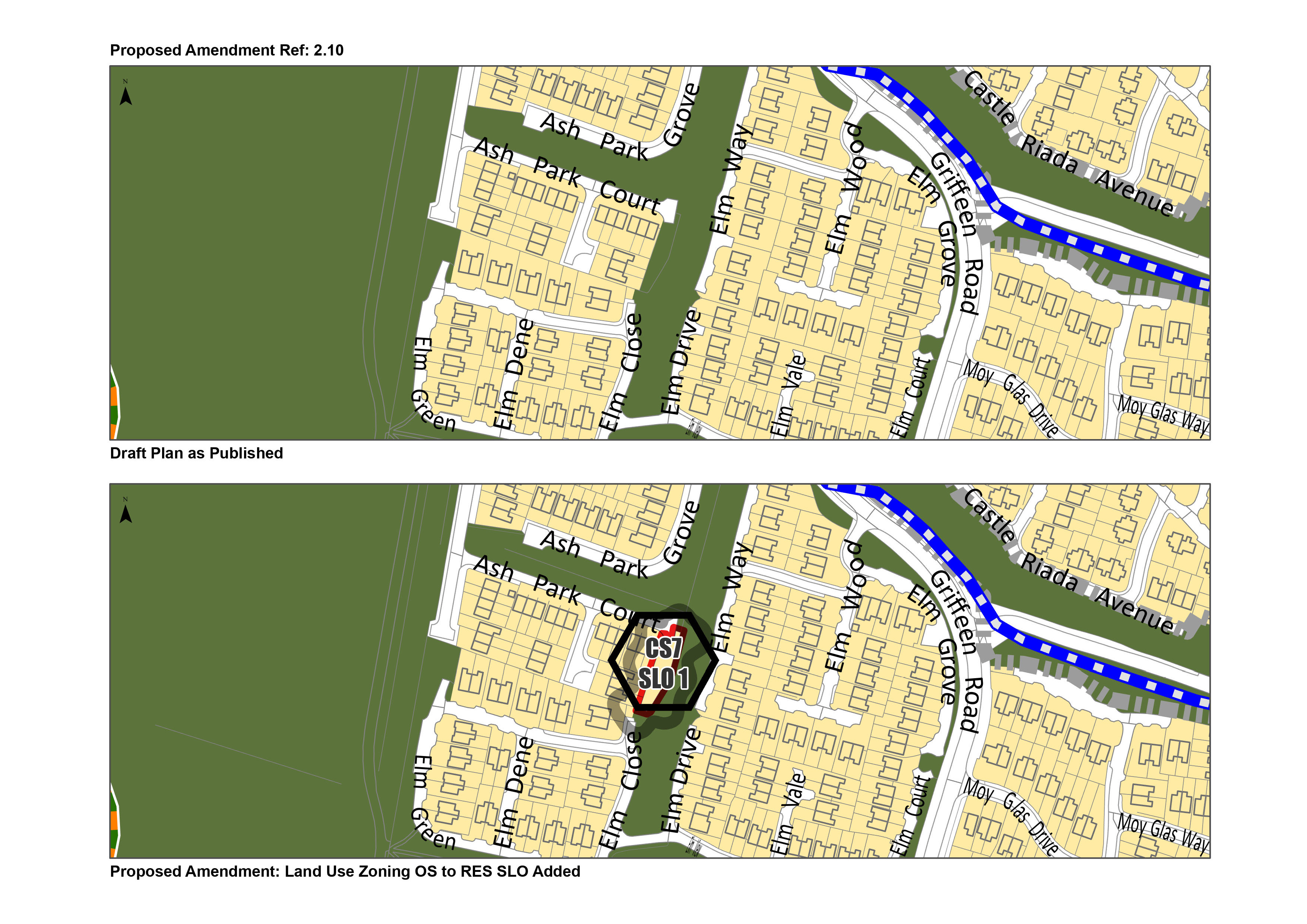
Amendment 2.10 |
| Page no. |
70 and Map No. 1 |
| Policy/Objective No. |
New CS7 SLO 1 - 2.7 Settlement Strategy And Amend Map No.1 |
| Text/Policy/Objective Amendment Wording | |
|
Insert a New CS7 SLO 1 to read: CS7 SLO 1: To provide low density housing on these zoned lands to the east of no. 36 Ash Park Court to a maximum of one housing unit, subject to all normal planning application requirements, ensuring the protection of nearby trees. AND Amend Map No. 1 to change from: Objective OS – Open Space – ‘To preserve and provide for open space and recreational amenities‘ to Objective RES - Existing Residential – ‘To protect and/or improve residential amenity’.
|
|
| Chapter/ Section | Section 2.7.2 Self-Sustaining Growth Towns / Self-Sustaining Town - Saggart |
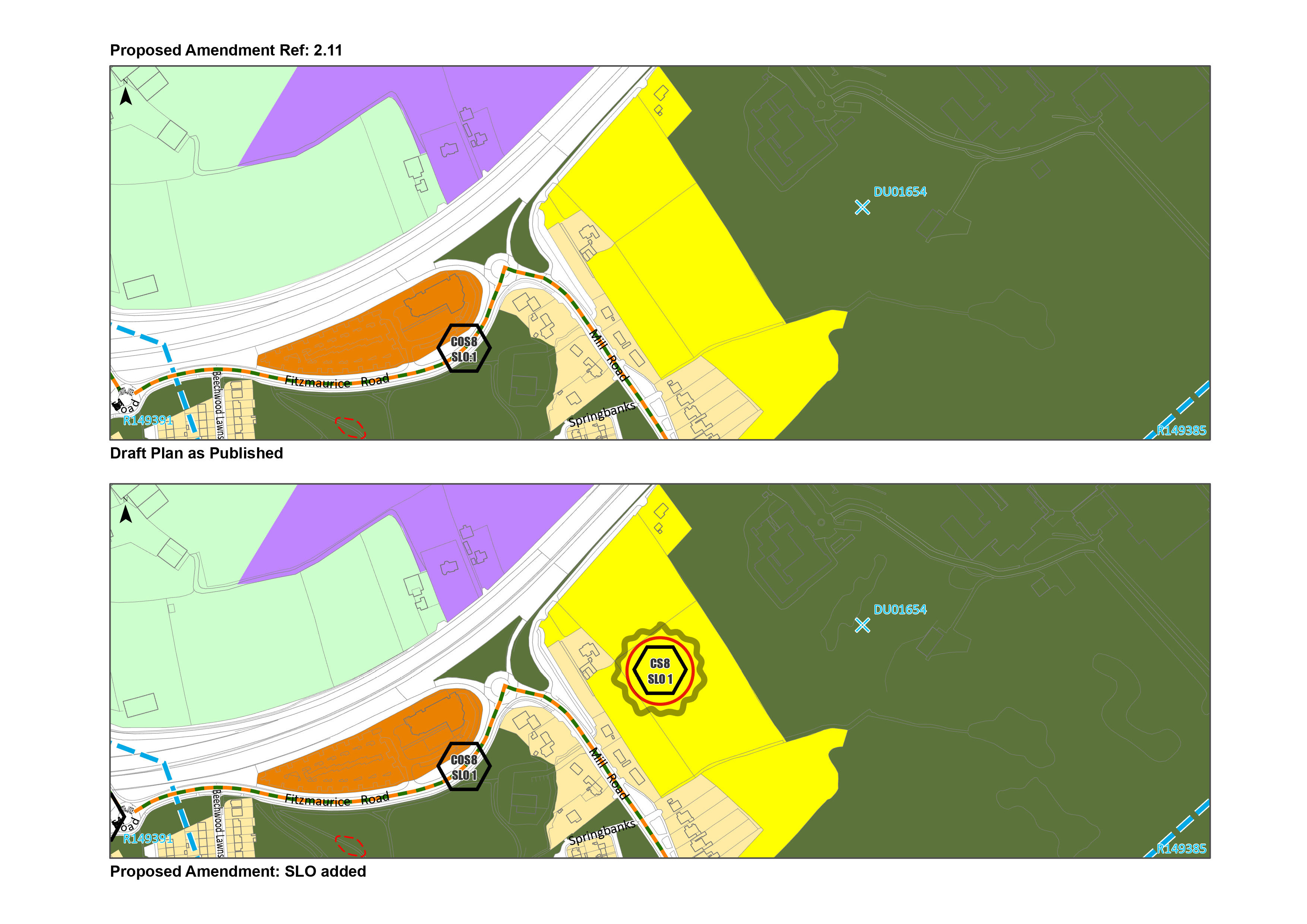
| Amendment ref. | Amendment 2.11 |
| Page no. |
70 |
| Policy/Objective No. | Text Change - 2.7.2 Self-Sustaining Growth Towns / Self-Sustaining Town |
| Text/Policy/Objective Amendment Wording | |
|
Amend text from: The Saggart settlement had a population in 2016 of 3,133 which is targeted to grow by 366 persons (11%) to 3,499 persons by 2028. To Read:
The Saggart settlement had a population in 2016 of 3,133 which is targeted to grow by |
|
| Chapter/ Section | Section 2.7.2 Self-Sustaining Growth Towns / Self-Sustaining Town - Saggart |
| Amendment ref. |
Amendment 2.11 |
| Page no. |
71 |
| Policy/Objective No. |
New CS8 SLO 1 - 2.7.2 Self-Sustaining Growth Towns / Self-Sustaining Town And Amend Map No. 8 |
| Text/Policy/Objective Amendment Wording | |
|
New CS8 SLO 1 to be added to read: CS8 SLO1: To facilitate the delivery of Phase 1 residential lands at Mill Road Saggart which fully integrates with the adjoining lands to the south and in tandem with the delivery of a park space centrally located on the subject lands, a play space, creche, the integration of strong cycling and pedestrian permeability proposals agreed to the satisfaction of the Planning Authority and the provision of appropriate noise mitigation measures along the northern boundary.
|
|
| Chapter/ Section | Section 2.7.2 Self-Sustaining Growth Towns / Self-Sustaining Town - Newcastle |
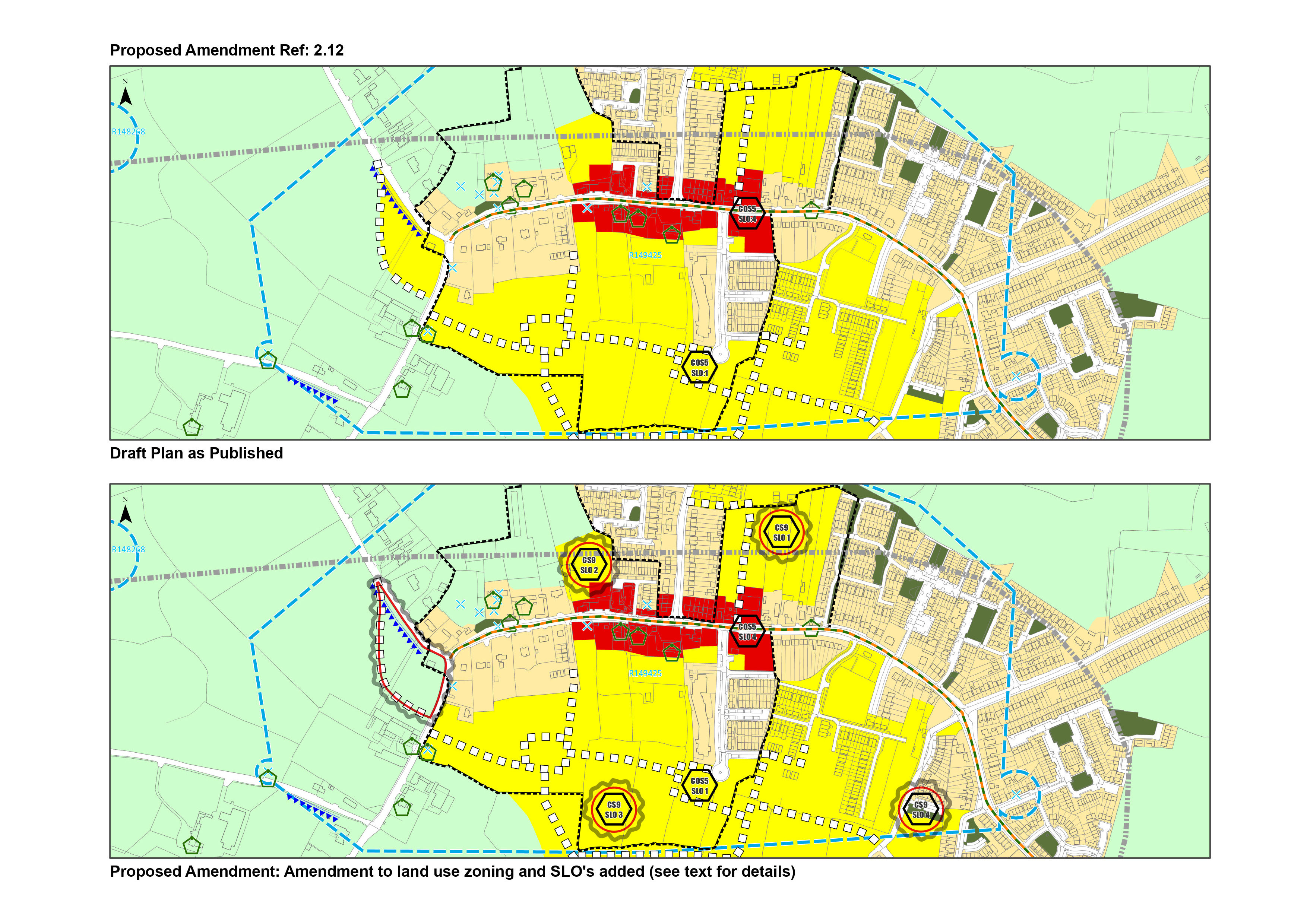
| Amendment ref. | Amendment 2.12 |
| Page no. |
71 |
| Policy/Objective No. | Text Change - 2.7.2 Self-Sustaining Growth Towns / Self-Sustaining Town |
| Consequential Amendment |
Consequential Amendment arising from Material Amendment 2.12 View Consequential Amendments [PDF] |
| Text/Policy/Objective Amendment Wording | |
|
Amend text from: The Newcastle settlement had a population in 2016 of 3,093 which is targeted to grow by 1,946 persons (+63%) to 5,039 persons by 2028. To Read:
The Newcastle settlement had a population in 2016 of 3,093 which is targeted to grow between the period 2022-2028 by |
|
| Chapter/ Section | Section 2.7.2 Self-Sustaining Growth Towns / Self-Sustaining Town - Newcastle |
| Amendment ref. | Amendment 2.12 |
| Page no. |
72 |
| Policy/Objective No. |
New CS9 Objective 4, CS9 SLO1, CS9 SLO2, CS9 SLO3, CS9 SLO4 - 2.7.2 Self-Sustaining Growth Towns / Self-Sustaining Town And Amend Map No. 7 |
| Consequential Amendment |
Consequential Amendment arising from Material Amendment 2.12 View Consequential Amendments [PDF] |
| Text/Policy/Objective Amendment Wording | |
|
Amend text from: The growth in Newcastle is mainly focused on the adopted Local Area Plan. It is estimated that the remaining units in current permissions will, at an average of 80 units per year, take 7 years to develop. The remaining LAP lands which could accommodate 886 units do not have permission to date. The continued growth of Newcastle will be dependent on the delivery of the phasing and infrastructure required in the LAP. The overarching principle for the town is to improve the social and physical services to provide for the growing population. To Read:
The growth in Newcastle is mainly focused on the adopted Local Area Plan. And New CS9 Objective 4, CS9 SLO1, CS9 SLO2, CS9 SLO3, CS9 SLO4 to be added to read: CS9 Objective 4: To facilitate and commit to the delivery of new residential development in a coordinated manner, ensuring alignment with investment infrastructure and supporting amenities and services. Such measures shall be delivered through appropriate phasing in line with CS9 SLO1, SLO2, SLO3 and SLO4. CS9 SLO1: To facilitate and commit to the delivery of Phase 1 residential lands at Burgage North in tandem with the delivery of 2 new street connections to main street and the provision of a new local park c. 0.3ha. CS9 SLO2: To facilitate and commit to the delivery of Phase 1 residential lands at Burgage North to the north of St. Finian’s Community Centre which reserve suitable lands to facilitate the extension of the existing community centre. CS9 SLO3: A sequentially phased programme to be submitted alongside any planning application on the subject lands which provides for the delivery of the following in tandem with development or as described 1) No more than 200 units to be permitted before the commencement of the remaining lands of c. 1.4ha to provide for the full Taobh Chnoic Park to the south 2) Urban Park/Square c. 1ha in size (Burgage South Park), 3) East-West Link Street, 4) Sean Feirm Park c. 0.2ha in size, 5) a portion of Tower House Park c. 0.1ha. All applications shall demonstrate to the satisfaction of the Planning Authority how they are supporting the delivery of North South Street connections to the Main Street. With regards delivery of a new primary school at Taobh Chnoic, the timing of this will be subject to educational needs in consultation with the Department of Education. Prior to completion of 200 units confirmation to be provided from the Department of Education on the transfer of lands to provide for the school, subject to their confirmation of need. CS9 SLO4: To commit to only facilitate the delivery of Phase 2 residential lands once identified infrastructure comprising of the Urban Park/Square c. 1ha in size, the additional 1.4ha for Taobh Chnoic Park and the East/West Link Street required within Phase 1 have been delivered to the satisfaction of the Planning Authority Rezone 1.3ha of lands to the west of Newcastle from RES-N – New Residential to RU – Rural at the junction of Athgoe and Hazelhatch Road. Amend Maps No. 7, insert new CS9 SLO 1 -3 relating to phase 1 lands and SLO 4 relating phase 2 lands and amend the zoning to the west of Newcastle from Res-N to RU.
|
|
| Chapter/ Section | Section 2.7.2 Self-Sustaining Growth Towns / Self-Sustaining Town – Rathcoole |
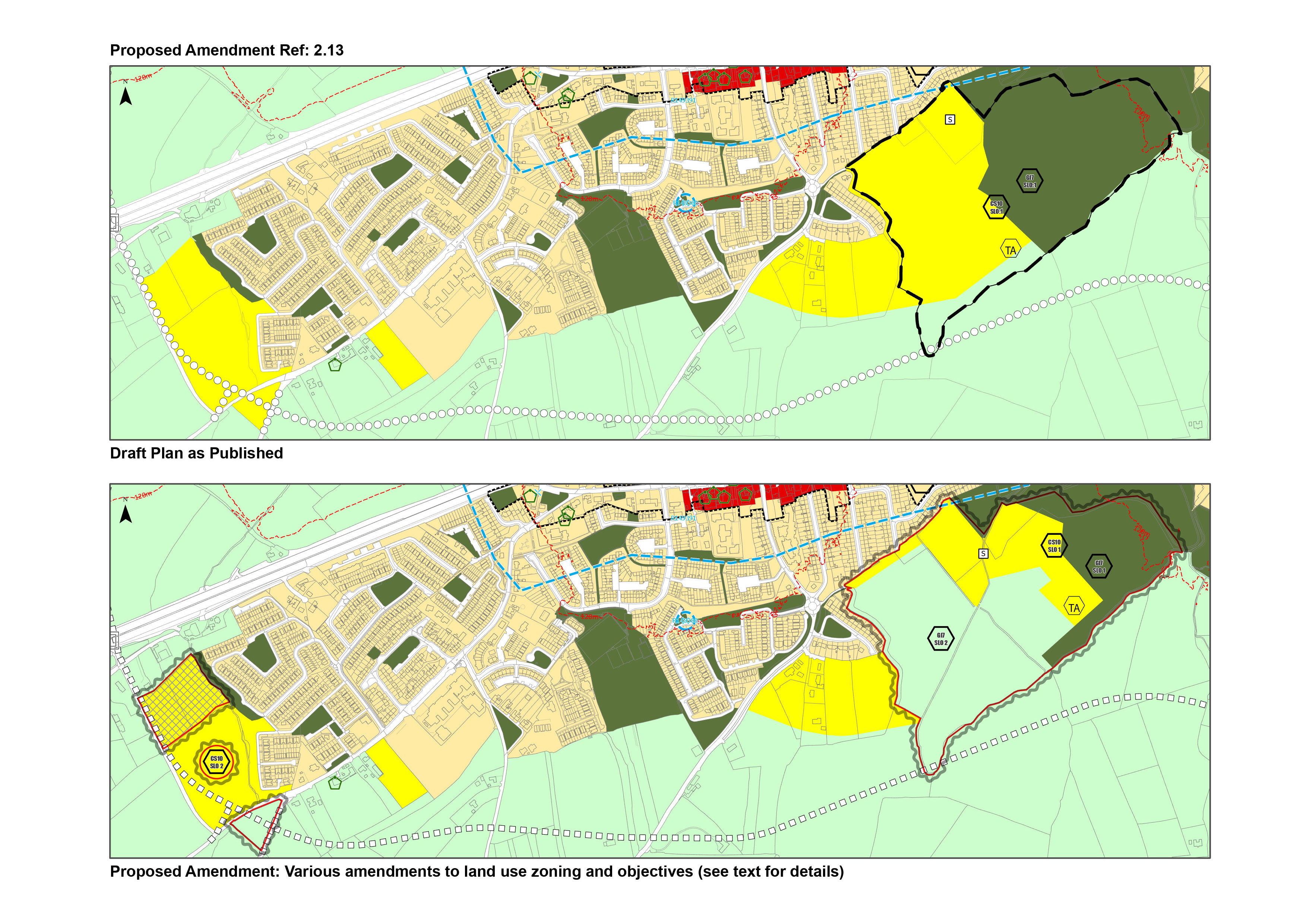
| Amendment ref. | Amendment 2.13 |
| Page no. |
73 |
| Policy/Objective No. | Text Change - 2.7.2 Self-Sustaining Growth Towns / Self-Sustaining Town |
| Consequential Amendment |
Consequential Amendment arising from Material Amendment 2.13. |
| Text/Policy/Objective Amendment Wording | |
|
Amend text from: The Rathcoole settlement had a population in 2016 of 4,351 which is targeted to grow by 2,058 persons (+47%) to 6,409 persons by 2028. To Read:
The Rathcoole settlement had a population in 2016 of 4,351 which is targeted to grow by |
|
| Chapter/ Section | Section 2.7.2 Self-Sustaining Growth Towns / Self-Sustaining Town – Rathcoole |
| Amendment ref. | Amendment 2.13 |
| Page no. |
73 |
| Policy/Objective No. |
New - 2.7.2 Self-Sustaining Growth Towns / Self-Sustaining Town And Amend Map 07 and 08 |
| Consequential Amendment |
Consequential Amendment arising from Material Amendment 2.13 View Consequential Amendments [PDF] |
| Text/Policy/Objective Amendment Wording | |
|
Amend text from: This level of growth is based on permissions available to commence within and adjoining the town and further growth will be at a rate that seeks to achieve a balance of service and infrastructure provision, focusing on consolidation along them main street. Rathcoole has limited public transport provision and social services to date. Some improvements will be made as BusConnects brings improved services and overall accessibility to Celbridge, Dublin City Centre, Grangecastle, Hazelhatch train station and Saggart Luas Stop. It is important that Rathcoole develops at an incremental pace, based on the delivery of social, physical and transport infrastructure and services. The capacity of zoned lands is considered to be sufficient to meet long term demand for the settlement. To Read:
This level of growth is based on Rathcoole has limited public transport provision and social services to date. Some improvements will be made as BusConnects brings improved services and overall accessibility to Celbridge, Dublin City Centre, Grangecastle, Hazelhatch train station and Saggart Luas Stop. It is important that Rathcoole develops through a phased approach and at an incremental pace, based on the delivery of social, physical and transport infrastructure and services. The capacity of zoned lands is considered to be sufficient to meet long term demand for the settlement. Delete CS10 SLO1:
And New CS10 Objective 4, CS10 SLO1 and CS10 SLO2 to be added to read: CS10 Objective 4: To facilitate the delivery of new residential development in coordinated manner, ensuring alignment with investment infrastructure and supporting amenities and services. Such measures shall be delivered through appropriate phasing in line with CS10 SLO1 and SLO2. CS10 SLO1 to be inserted on the lands adjacent to Rathcoole Park: To ensure that the provision of a primary school, library hub, 2 full sized GAA pitches and 1 junior pitch and associated pavilion, access road and open space is provided in tandem with new residential development. CS10 SLO2 to be inserted on lands to the west of Rathcoole: To ensure the delivery of the necessary upgrades to the existing road to the west of the site being delivered in tandem with development. Development shall also provide for an appropriately landscaped riparian corridor along the eastern boundary of the subject lands and associated landscaping throughout the site. And: Amend Maps No. 7 and No. 8 revising the zoning as indicated in the maps below from RES N New Residential to RU Rural, from OS Open Space to RU Rural, from OS Open Space to RES-N New Residential on lands adjacent to Rathcoole Park to the southeast of Rathcoole and removing the boundary of CS10 SLO1, Adjusting the location of the school site and Traveller Accommodation map based objectives to reflect CS10 Objective 4, new CS10 SLO1 and CS10 SLO2. Amend the zoning to the west of Rathcoole from Res-N to Strategic Residential Reserve Lands and from RES-N New Residential to RU Rural.
|
|
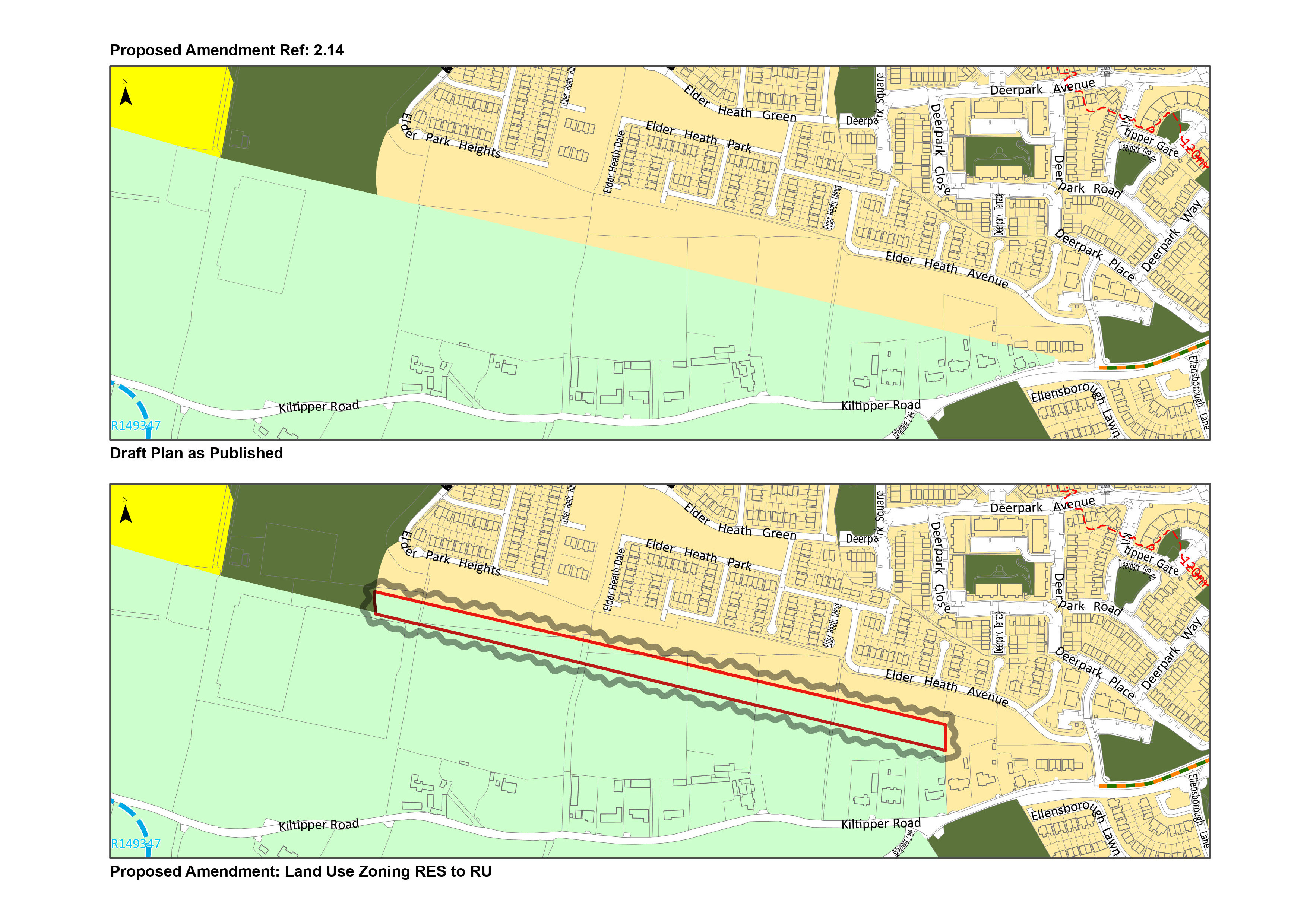
| Chapter/ Section | Individual Zoning Amendment |
| Amendment ref. | Amendment 2.14 |
| Page no. |
Map No. 9 |
| Policy/Objective No. | Map No. 9 – Elder Heath |
| Text/Policy/Objective Amendment Wording | |
|
Amend Map No. 9 from zoning Objective RES - Existing Residential to accurately align with 60m clearance and safety zone of the existing Carrickmines-Dunstown 220kV transmission line. And Amend Map No. 9 to rezone where the lands extended south beyond the 60m clearance, Objective RU - ‘To protect and improve rural amenity and to provide for the development of agriculture’ to align with the remaining lands to the south.
|
|
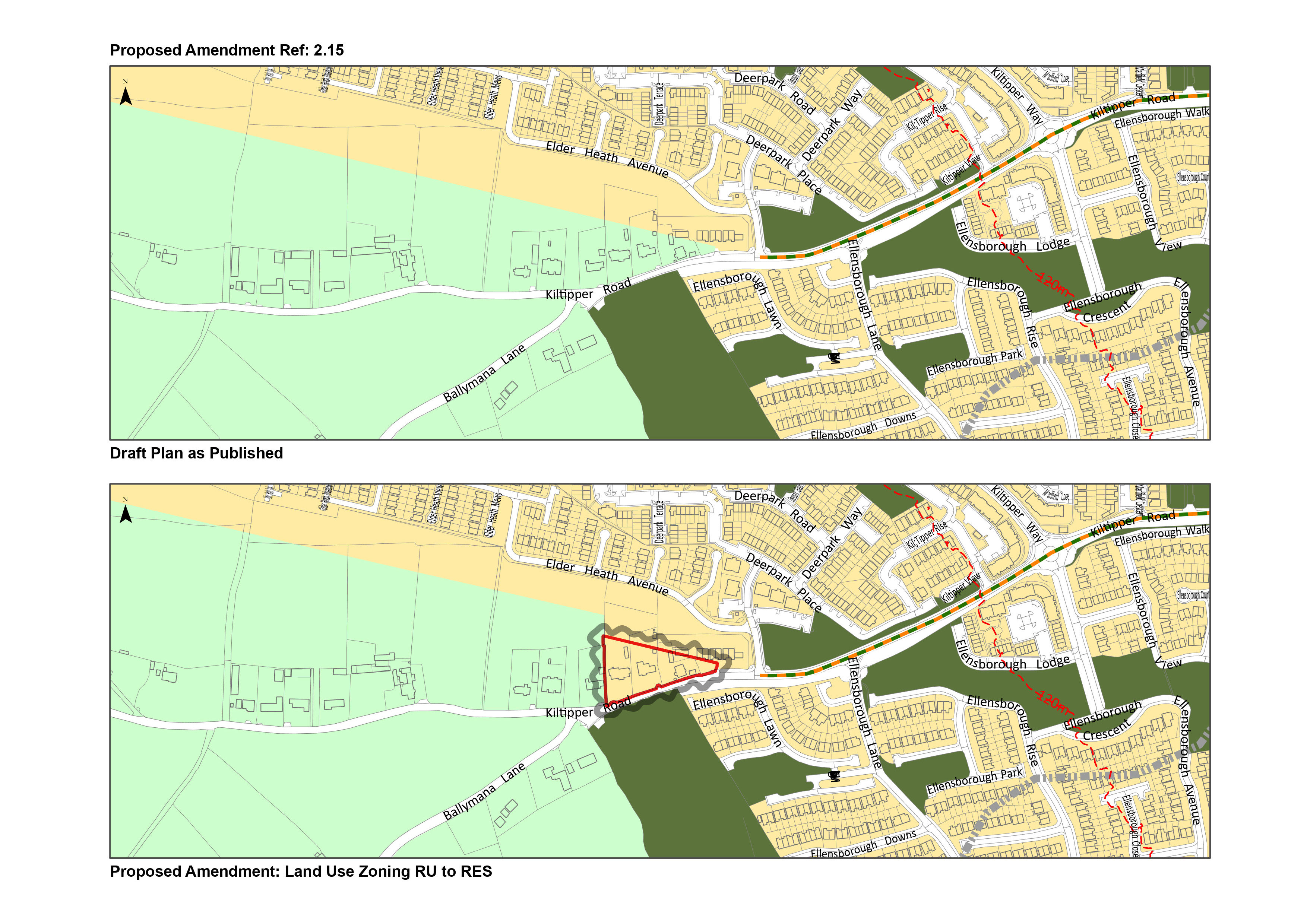
| Chapter/ Section | Individual Zoning Amendment |
| Amendment ref. | Amendment 2.15 |
| Page no. |
Map No.9 |
| Policy/Objective No. | Map No. 9 – Kiltipper Road |
| Text/Policy/Objective Amendment Wording | |
|
Amend Map No. 9 from Objective RU – Rural and Agriculture– ‘To protect and improve rural amenity and to provide for the development of agriculture ‘ To Objective RES - Existing Residential – ‘To protect and/or improve residential amenity’
|
|
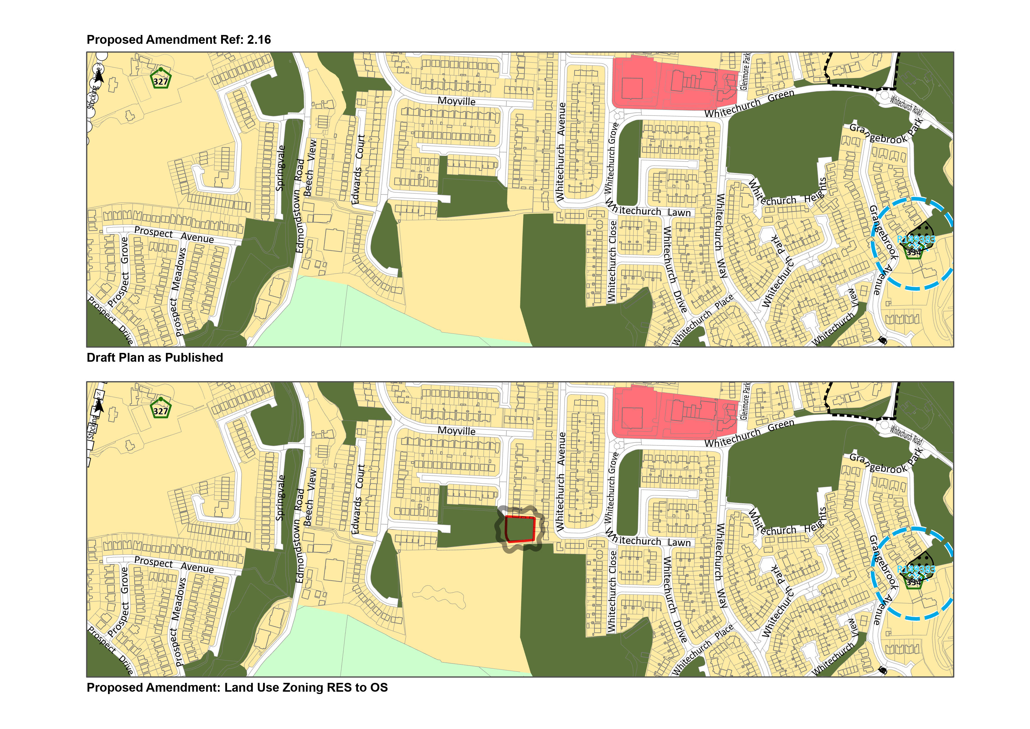
| Chapter/ Section | Individual Zoning Amendment |
| Amendment ref. | Amendment 2.16 |
| Page no. |
Map no. 10 |
| Policy/Objective No. | Map No. 10 - Moyville |
| Text/Policy/Objective Amendment Wording | |
|
Amend Map No. 10 to change from: Objective RES - Existing Residential – ‘To protect and/or improve residential amenity’. To Objective OS – Open Space – ‘To preserve and provide for open space and recreational amenities‘
|
|
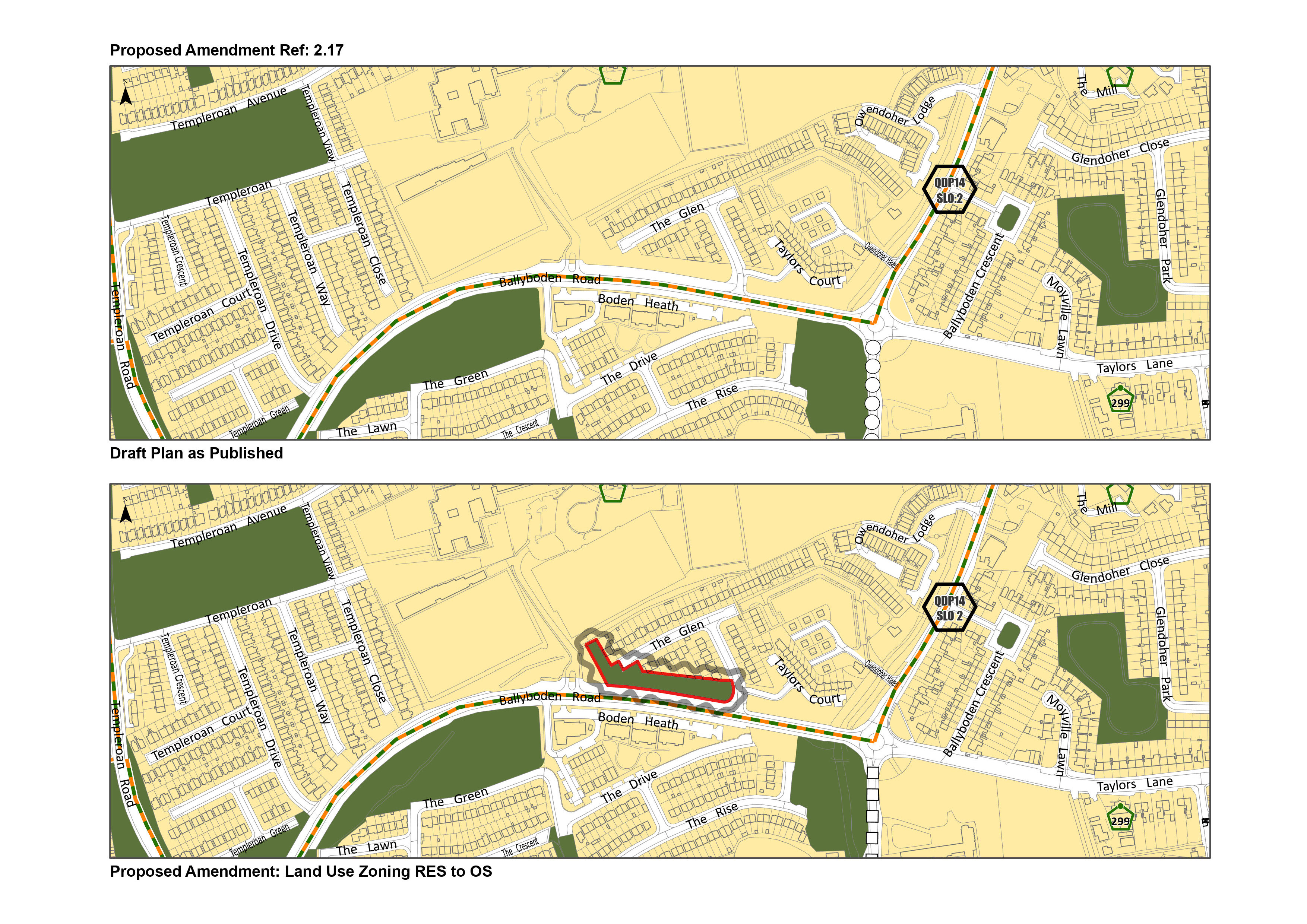
| Chapter/ Section | Individual Zoning Amendment |
| Amendment ref. | Amendment 2.17 |
| Page no. |
Map No. 10 |
| Policy/Objective No. | Map. No 10 – The Glen |
| Text/Policy/Objective Amendment Wording | |
|
Amend Map No. 10 to change from: Objective RES - Existing Residential – ‘To protect and/or improve residential amenity’. To Objective OS – Open Space – ‘To preserve and provide for open space and recreational amenities‘
|
|
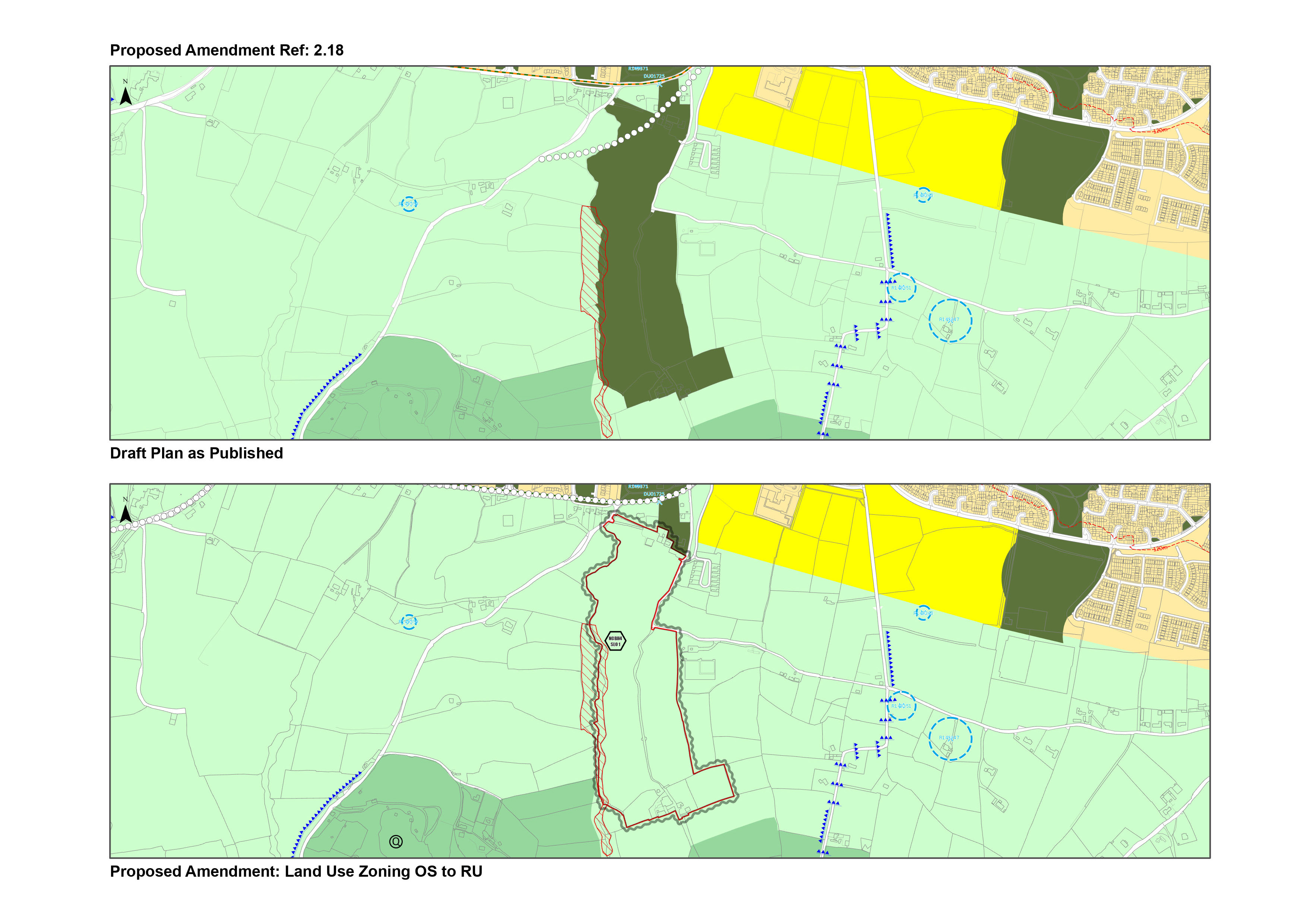
| Chapter/ Section | Individual Zoning Amendment |
| Amendment ref. | Amendment 2.18 |
| Page no. |
Map No.8 |
| Policy/Objective No. | Map No. 8 – Mount Seskin |
| Text/Policy/Objective Amendment Wording | |
|
Amend Map No. 8 to change from Objective OS – Open Space – ‘To preserve and provide for open space and recreational amenities‘ To Objective RU - ‘To protect and improve rural amenity and to provide for the development of agriculture’
|
|
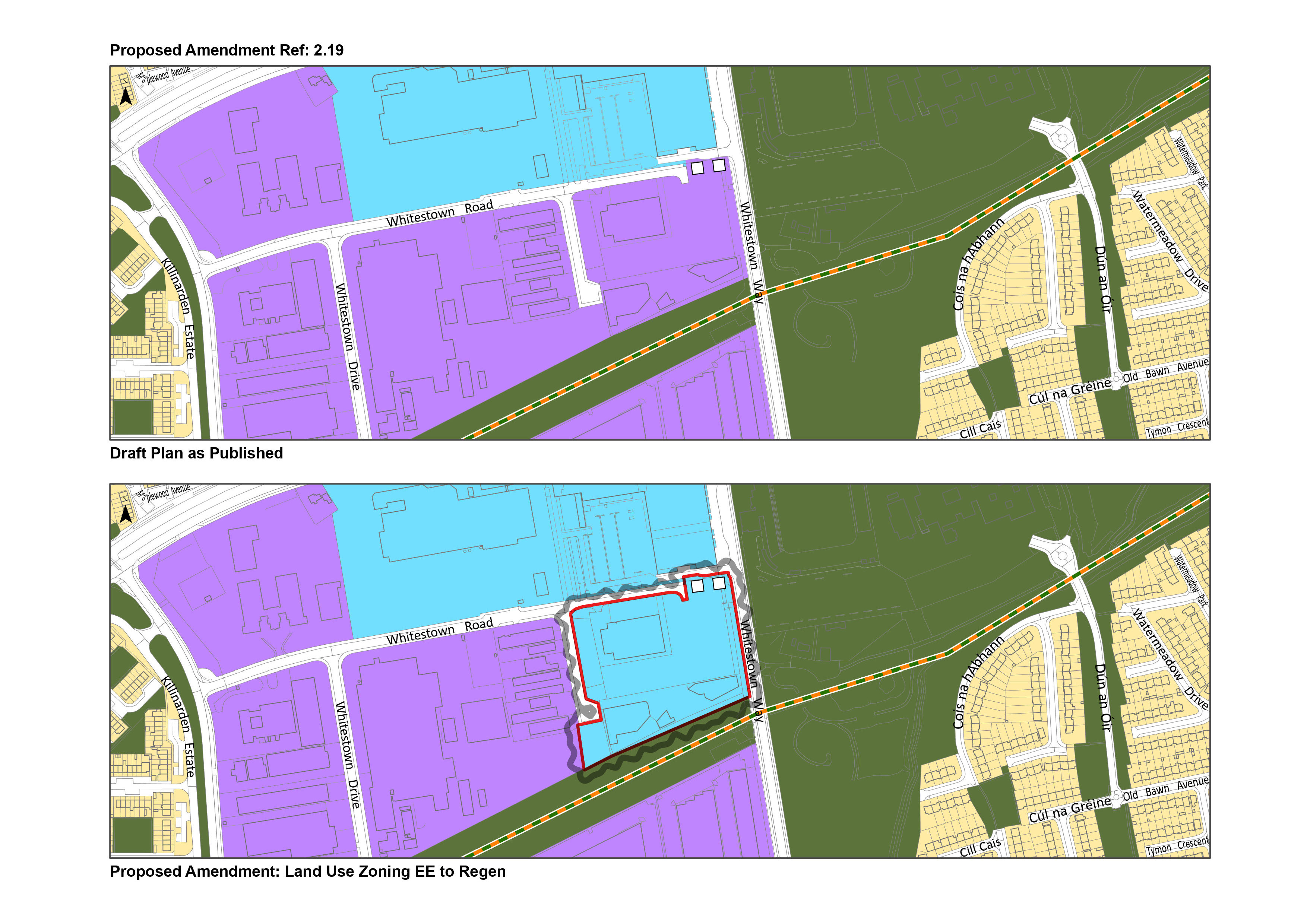
| Chapter/ Section | Individual Zoning Amendment |
| Amendment ref. | Amendment 2.19 |
| Page no. |
Map No. 9 |
| Policy/Objective No. | Map. No 9 – Whitestown Way |
| Text/Policy/Objective Amendment Wording | |
|
Amend Map 9 to change from: Objective EE – ‘To provide for enterprise and employment related uses’ To Objective REGEN – ‘To facilitate enterprise and/or residential led regeneration subject to a development framework or plan for the area incorporating phasing and infrastructure delivery.’
|
|
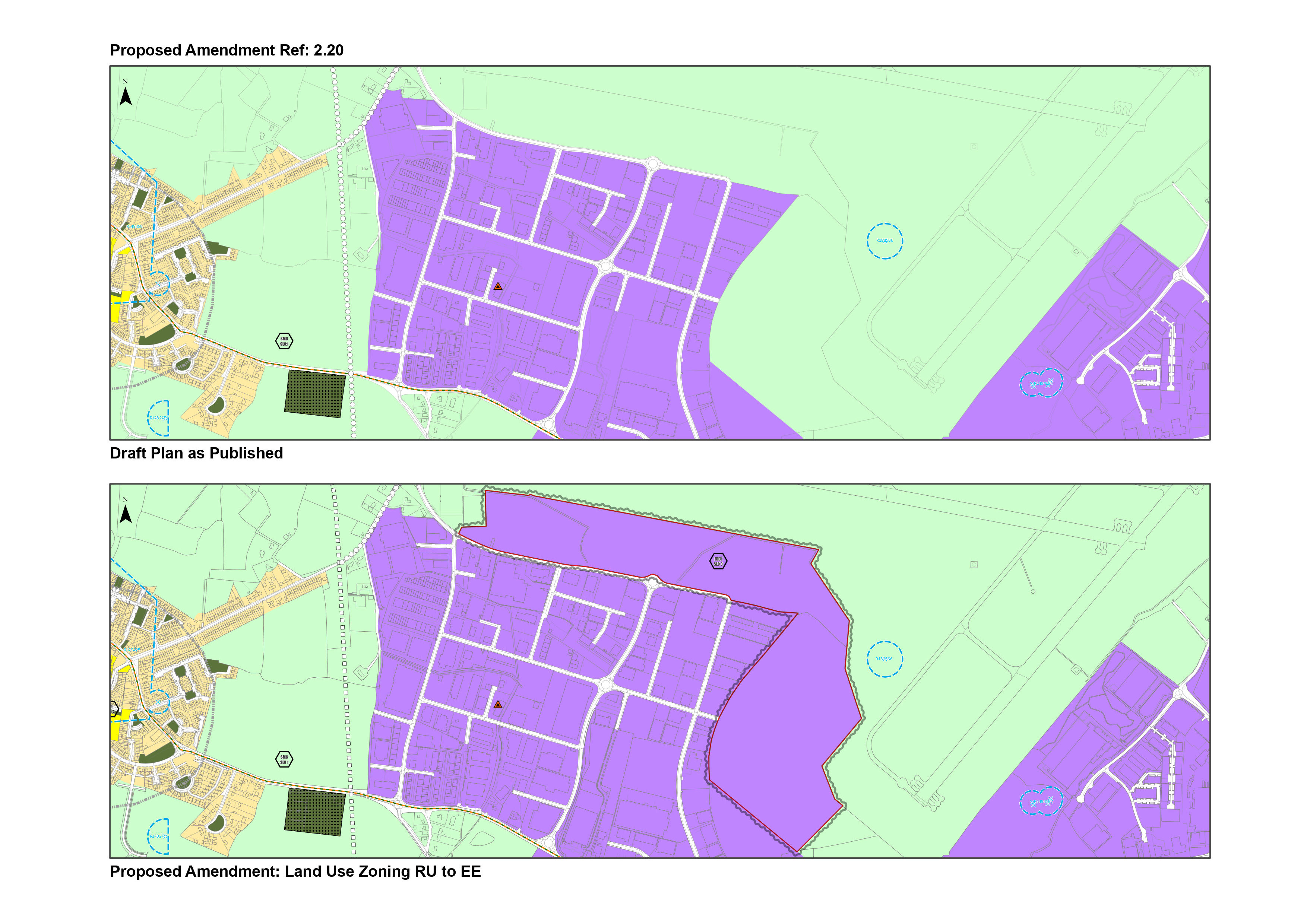
| Chapter/ Section | Individual Zoning Amendment |
| Amendment ref. | Amendment 2.20 |
| Page no. |
Map No’s 4 and 8 |
| Policy/Objective No. | Map No’s 4 and 8 - Greenogue |
| Text/Policy/Objective Amendment Wording | |
|
Amend Map No. 4 and No. 8 From Objective RU – ‘To protect and improve rural amenity and to provide for the development of agriculture’ To: Objective EE – ‘To provide for enterprise and employment related uses’ Note Specific Local Objective for these additional employment lands. See Amendment Ref. 9.4.
|
|
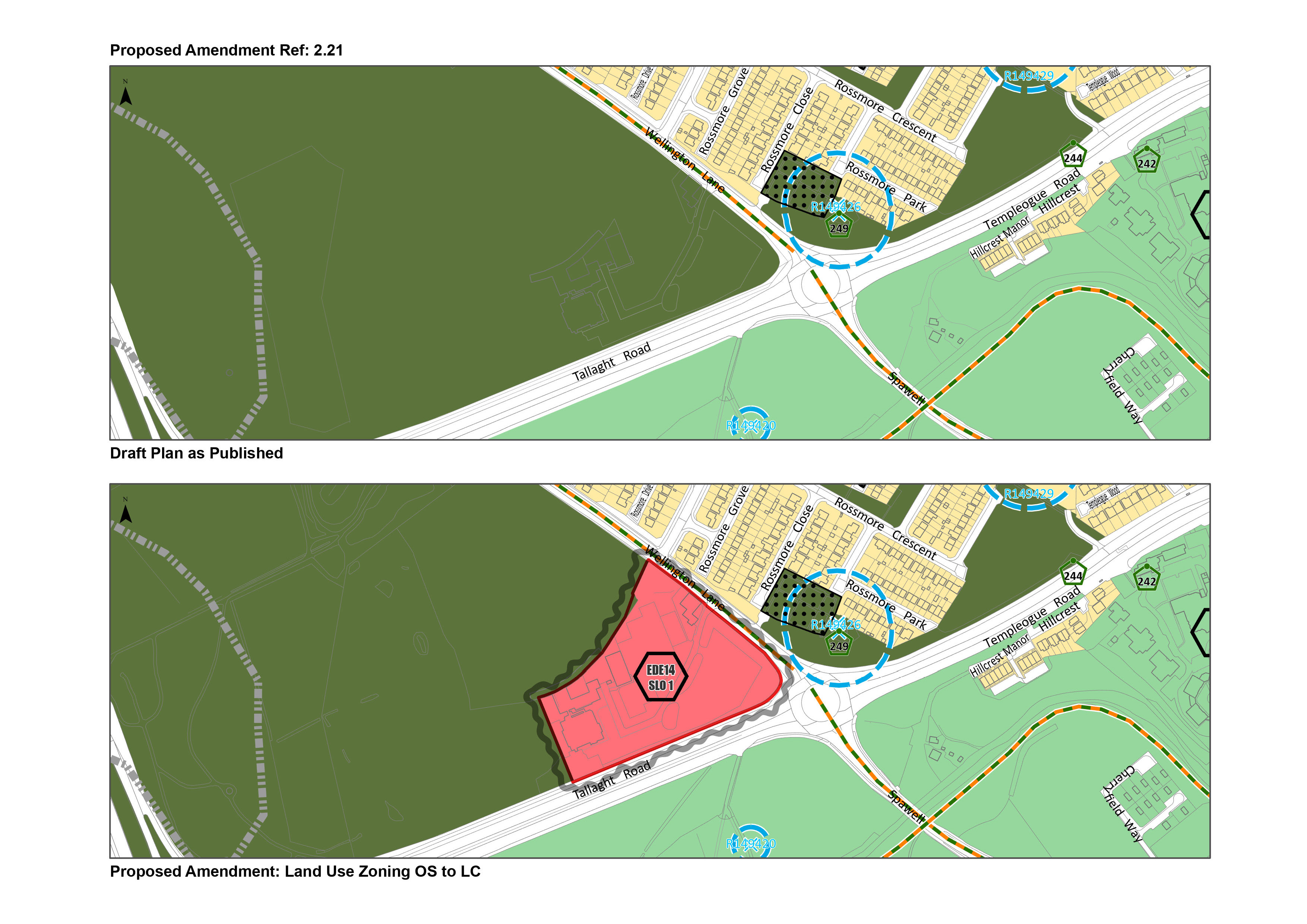
| Chapter/ Section | Individual Zoning Amendment |
| Amendment ref. | Amendment 2.21 |
| Page no. |
Map No. 6 |
| Policy/Objective No. | Map No. 6 - Spawell |
| Text/Policy/Objective Amendment Wording | |
|
Amend Map No. 6 From: Objective OS – Open Space – ‘To preserve and provide for open space and recreational amenities‘ To: Objective LC – Local Centre – ‘To protect, improve and provide for the future development of Local Centres’ Note: Specific Local Objective for these additional Local Centre lands. See Amendment Ref. 9.11.
|
|
Contents
Materials
Observations
Observations
Amend Maps revising the zoning as indicated in the area bordered in red in the attached map from RU Rural to RES N New Residential on lands adjacent to Rathcoole Park to the southeast of Rathcoole.
I wish to make a submission to the public consultation regarding:
Section 2.7.2 Self-Sustaining Growth Towns / Self-Sustaining Town – Rathcoole
Amendment 2.13
Page 73
I am asking for...
I welcome the opportunity to make a submission to the public consultation regarding:
Section 2.7.2 Self-Sustaining Growth Towns / Self-Sustaining Town – Rathcoole...