Ref Section 4.2.5 Landscape, Natural, Cultural and Built Heritage Amendment 4.9
I ask that the Development Plan ensures that detailed habitat classifications are recorded prior to zoning land...
Chapter 4: Green Infrastructure
Closed29 Mar, 2022, 00:00 - 26 Apr, 2022, 23:59
Following are the proposed material amendments to Chapter 4.
| Chapter/ Section |
4.2.1 Biodiversity - GI 2 Objective 5 |
| Amendment ref. |
Amendment 4.1 |
| Page no. |
141 |
| Policy/Objective No. |
Amend Section GI2 Objective 5 |
| Text/Policy/Objective Amendment Wording | |
|
Amend Section GI2 Objective 5 as follows: From: GI2 Objective 5: To protect and enhance the County’s hedgerow network, in particular hedgerows that form townland, parish and barony boundaries recognising their historic and cultural importance in addition to their ecological importance and increase hedgerow coverage using locally native species including a commitment for no net loss of hedgerows on any development site and to take a proactive approach to protection and enforcement. To read: GI2 Objective 5: To protect and enhance the County’s hedgerow network, in particular hedgerows that form townland, parish and barony boundaries recognising their historic and cultural importance in addition to their ecological importance and increase hedgerow coverage using locally native species including a commitment for no net loss of hedgerows on any development site and to take a proactive approach to protection and enforcement, such proactive approach to include provision to inspect development sites post construction to ensure hedgerow coverage has been protected as per the plan. |
|
| Chapter/ Section | 4.2.1 Biodiversity - GI 2 Objective 9 |
| Amendment ref. |
Amendment 4.2 |
| Page no. |
141 |
| Policy/Objective No. |
Amend Section GI2 Objective 9 |
| Text/Policy/Objective Amendment Wording | |
|
Amend Section GI2 Objective 9 as follows: From: GI2 Objective 9: To exploit the full potential of existing underutilised perimeter and border park spaces through the augmentation of wild grasses and other naturally occurring vegetation that enhance local area biodiversity and habitats in support of the National Pollinator Plan and to consider wildflower meadows where beneficial to biodiversity. To read: GI2 Objective 9: To exploit examine where appropriate the full potential of landfill sites and quarries as well as existing underutilised perimeter and border park spaces through the augmentation of wild grasses and other naturally occurring vegetation that enhance local area biodiversity and habitats in support of the National Pollinator Plan and to consider wildflower meadows where beneficial to biodiversity. |
|
| Chapter/ Section | 4.2.3 Climate Resilience |
| Amendment ref. | Amendment 4.3 |
| Page no. |
146 |
| Policy/Objective No. |
Amend Section 4.2 |
| Text/Policy/Objective Amendment Wording | |
|
Amend Section 4.2 as follows: From: Urban Greening Urban Greening Interventions which modify the quality, quantity and accessibility of urban green spaces is described as Urban Greening. Urban Greening can be achieved by establishing new urban spaces or by changing the characteristics of existing ones. The process can refer to a broad spectrum of measures which can be implemented at different scales in private or public spaces. These can include, pocket parks, urban gardens, green roofs/walls, recreational and urban/community gardening and may include facilitated access to urban woodlands, forests and natural wildlife areas. Urban greening helps combat air and noise pollution, soaks up rainwater that may otherwise create flooding, creates a habitat for local wildlife, and has been shown to lift morale in the people who see it, calming traffic and there is some evidence that it can lessen urban crime. Urban Greening is often implemented through the development of an Urban Greening Factor (UGF) or Green Space Factor (GSP)This is a tool that evaluates and quantifies the amount and quality of urban greening that a scheme provides to inform decisions about appropriate levels of greening in new developments. It is based on a range of agreed factors which contribute to greening of an area for example green roof/wall, tree planting, provision of semi-natural vegetation, provision of wildflower meadows, water features, hedge and tree planting etc. The output for a particular development is the achievement of a target score based on assigned scores to agreed interventions. To read: Urban Greening Interventions which raise the quality of and modify the quantity and accessibility of urban green spaces are described as Urban Greening. Urban Greening can be achieved by establishing new urban spaces or by changing the characteristics of existing ones. The process can refer to a broad spectrum of measures which can be implemented at different scales in private or public spaces. These can include, pocket parks, urban gardens, green roofs/walls, recreational and urban/community gardening, natural (SuDS) and may include facilitated access to urban woodlands, forests and natural wildlife areas. Urban greening helps combat air and noise pollution, soaks up rainwater that may otherwise create flooding, creates a habitat for local wildlife, and has shown to lift morale in the people who see it, calming traffic and there is some evidence that it can lessen urban crime. This process is implemented through the application of a Green Space Factor. Green Space Factor (GSF) The quantity and quality of green infrastructure provided by new development will be improved by the implementation of a Green Space Factor (GSF) for South Dublin. The GSF is a measurement that describes the quantity and quality of landscaping and GI across a defined spatial area. This measurement comprises a ratio that compares the amount of green space to the amount of impermeable ‘grey’ space in a subject site. As a planning tool, this ratio is used to assess both the existing green cover within a site and the impact of new development, based on the quantity and quality of new green space provided. Greening factors have been adopted and implemented across the UK, Europe and the United States to help ensure that new development makes a positive contribution to the local environment. By ensuring that new development meets minimum standards for the provision of GI the GSF aims to secure a positive contribution to biodiversity, amenity, air quality, stormwater management, temperature regulation and other ecosystem services. The GSF prioritises the retention of existing GI features within a subject site, in order to support the protection of the County’s existing GI network. At the same time, the GSF will ensure that new development incorporates new landscaping and GI features, contributing to the enhancement of the overall GI network. Chapter 13, section 13.3.2 provides further detail on the requirements for the GSF as part of planning applications. Amend Section 13.3.2 Green Infrastructure and Development Management under ‘Greening Factor’ From Greening Factor GI Proposals will be assessed against the policies and objectives contained within the Green Infrastructure Strategy set out in the County Development Plan and the 16 Proposed CE Amendments Greening Factor outlined below: “An urban greening factor is a ratio between the amount of built area and non-built area within an urban area. The urban greening factor tool is used to assess and quantify the amount and quality of urban greening that a scheme provides”. An urban greening factor will be developed and applied during the lifetime of the Plan to all applications based on the submitted GI Infrastructure Plans and Landscape Plans. The urban greening factor will incorporate an appropriate scoring mechanism for greening urban areas based on best international practice and the unique GI features of the County. To Green Space Factor (GSF) The GSF is a score-based requirement that establishes minimum standards for landscaping and GI provision in new developments (See Table 1 in Green Space Factor Guidance Note). Minimum scoring requirements are based on the land-use zoning of a site (See GI5 Objective 4), this applies to all development comprising 2 or more residential units and any development with a floor area in excess of 500 sq.metres. Qualifying developments are required to reach the minimum Green Space Factor (GSF)score established by their land use zoning. Developers can improve their score by both retaining and enhancing existing landscape features and incorporating new features. A developer will be required to specify the Green Space Factor (GSF) measure included within a proposed development as part of the submitted Green Infrastructure Plan and Landscape Plan. To facilitate the evaluation of the GSF score for a proposed development the Council will make available a Green Space Factor (GSF) Worksheet to applicants which will be required to be submitted with a qualifying planning application. A Green Space Factor (GSF) Guidance Note will also be made available on the Council’s website under the Development Plan section setting out the applicable weightings and scorings. This will allow developers to calculate the overall site area and the surface areas of contributing to the Green Space Factor (GSF)s to see whether a proposed development achieves the required minimum score. Where applicable, a completed worksheet shall be submitted with the Green Infrastructure Plan and Landscape Plan in support of a proposed development. Minimum Score Not Achieved In cases where proposed development does not meet the minimum required score and the Council agree that the minimum score is not achievable on the site; the Council will engage with the applicant to help determine an alternative GI solution, to ensure that the proposed development does not detract from the local environment and makes a positive contribution to local GI provision. Where 17 Proposed CE Amendments site-specific constraints do not allow for adequate landscaping features in line with minimum requirements (e.g. for infill development or certain brownfield sites) a developer will be permitted to provide alternative GI interventions or contributions to make up for this shortcoming, see below. Those GI measures ultimately chosen will be dictated by the site-specific context and will be subject to agreement with Council. Sites with a Particular Sensitivity Further, where a subject site is considered to be particularly sensitive or valuable from a GI perspective, developers will be required to engage with the Council to determine those GI interventions that will be required to ensure the environmental integrity of the site. This will primarily apply to sites located within or adjacent to primary and secondary GI corridors (see Figure 4.4). In such cases, specific consideration will be required to ensure that development does not fracture the existing GI network and preserves or enhances connectivity. Such sites may require the implementation of additional site-specific interventions to reflect their value. Alternative GI Interventions As indicated above, in cases where an applicant / developer faces particular difficulties in meeting the required minimum score due to site specific constraints, the Council will engage with the applicant to help determine an alternative GI solution to make up for any shortcoming. The following comprises a non-exhaustive list of interventions that developers can implement in order to enhance GI in the local area. — The use of natural features such as woodlands, hedgerows, trees, water courses, ponds and grasslands or other natural methods to strengthen GI assets and provide connections to the wider GI network. — The incorporation of nature-based solutions such as SuDS schemes, permeable paving, green and blue roofs, green walls, swales, SuDS tree pits, raingardens, ponds to support local biodiversity and mitigate potentially harmful effects of development — The provision of new native tree and plant species as well as pollinator friendly species within developments, consistent with National Pollinator Plan. — Where possible, no net loss of existing trees/hedgerows on site. — The provision of bird boxes (as building façades for nesting sparrows or swift bricks), bat boxes, hedgehog passes, and other wildlife interventions as required in landscape settings. — The provision of bee bricks in new development. — The retention of heritage features such as old walls, bridges etc. that have habitat value. — The provision of allotments/orchards for residents to grow fruits and vegetables. — Use of recycled/upcycled or locally sourced natural materials within the development. — GI management/maintenance plans to be included as part of the landscape plans submitted for the Planning process. May include hedgerow/ tree and grassland management plans. 18 Proposed CE Amendments — The provision of environmentally sensitive recreation and connectivity between GI areas. Those GI measures ultimately chosen will be dictated by the site-specific context and will be subject to agreement with the Council. And Delete section 13.3.3 Green Infrastructure Interventions and renumber remaining sections accordingly. |
|
| Chapter/ Section | 4.2.3 Climate Resilience - GI 5 Objective 4 |
| Amendment ref. | Amendment 4.4 |
| Page no. |
148 |
| Policy/Objective No. |
Amend Section GI5 Objective 4 |
| Text/Policy/Objective Amendment Wording | |
|
Amend Section GI5 Objective 4 as follows: From: GI5 Objective 4: To implement an urban greening factor for all new developments subject to an appropriate scoring mechanism being developed for the County based on best international standards and its appropriate application to the unique features of the County. Developers will be required to demonstrate how they have achieved urban greening targets based on the scoring mechanism developed through relevant interventions as part of the proposed development. (See Chapter 13 Implementation and Monitoring). To read: To implement the Green Space Factor (GSF) for all qualifying development comprising 2 or more residential units and any development with a floor area in excess of 500 sq.metres. Developers will be required to demonstrate how they can achieve a minimum Green Space Factor (GSF) scoring requirements based on best international standards and the unique features of the County’s GI network. Compliance will be demonstrated through the submission of a Green Space Factor (GSF) Worksheet (see Chapter 13 Implementation and Monitoring, Section 13.3.2). |
|
| Chapter/ Section | Section 4.2.3 Climate Resilience |
| Amendment ref. | Amendment 4.5 |
| Page no. |
149 |
| Policy/Objective No. |
Amend Wording of GI5 Objective 6 |
| Text/Policy/Objective Amendment Wording | |
|
Amend Section 4.2.3 Climate Resilience as follows: From: GI5 Objective 6: To provide more tree cover across the county, in particular to areas that are lacking trees. To Read: GI5 Objective 6: To provide more tree cover across the county, in particular to areas that are lacking trees with an emphasis on planting native Irish trees as appropriate. |
|
| Chapter/ Section | Section 4.2.3 Climate Resilience |
| Amendment ref. | Amendment 4.6 |
| Page no. |
149 |
| Policy/Objective No. | Amend GI5 to add a new objective |
| Text/Policy/Objective Amendment Wording | |
|
Amend Section GI5 to add a new objective as follows: To complete a flood risk assessment for Saggart with a view to restoring and protecting existing biodiversity, ecosystems and drain systems. |
|
| Chapter/ Section |
Section 4.2.4 Recreation and Amenity (Human Health and Wellbeing) Section 4.3.1 Components of the GI Network Section 4.3.2 Table 4.1: Strategic Corridor 1: The Dodder River |
| Amendment ref. | Amendment 4.7 |
| Page no. |
149 |
| Policy/Objective No. |
Amend Section 4.2.4 Recreation and Amenity (Human Health and Wellbeing) Amend Section 4.3.1 Components of the GI Network Amend Section 4.3.2 Table 4.1: Strategic Corridor 1: The Dodder River |
| Text/Policy/Objective Amendment Wording | |
|
Amend the following Sections: Section 4.2.4 Recreation and Amenity (Human Health and Wellbeing) Section 4.3.1 Components of the GI Network Section 4.3.2 Table 4.1: Strategic Corridor 1: The Dodder River to insert the following text ‘within the Wicklow Mountains National Park’ where reference is made to the Dublin Mountains, where relevant. And Amend Section 4.3.2 Table 4.1: Strategic Corridor 1: The Dodder River Where text refers to Dublin / Wicklow Mountains amend text to read as follows: Dublin / Wicklow Mountains within the Wicklow Mountains National Park |
|
| Chapter/ Section |
Section 4.2.4 Recreation and Amenity (Human Health and Wellbeing)ng) |
| Amendment ref. | Amendment 4.8 |
| Page no. |
152 |
| Policy/Objective No. |
Amend Section to add an additional Objective: GI6 Objective 11 |
| Text/Policy/Objective Amendment Wording | |
|
Add new objective under Policy GI6 to read: Objective: GI6 Objective 11 To support appropriate human engagement including the sensory experience of rivers and waterways, through access to viewing points and fishing spots, having regard to the primary need for environmental and biodiversity protection. |
|
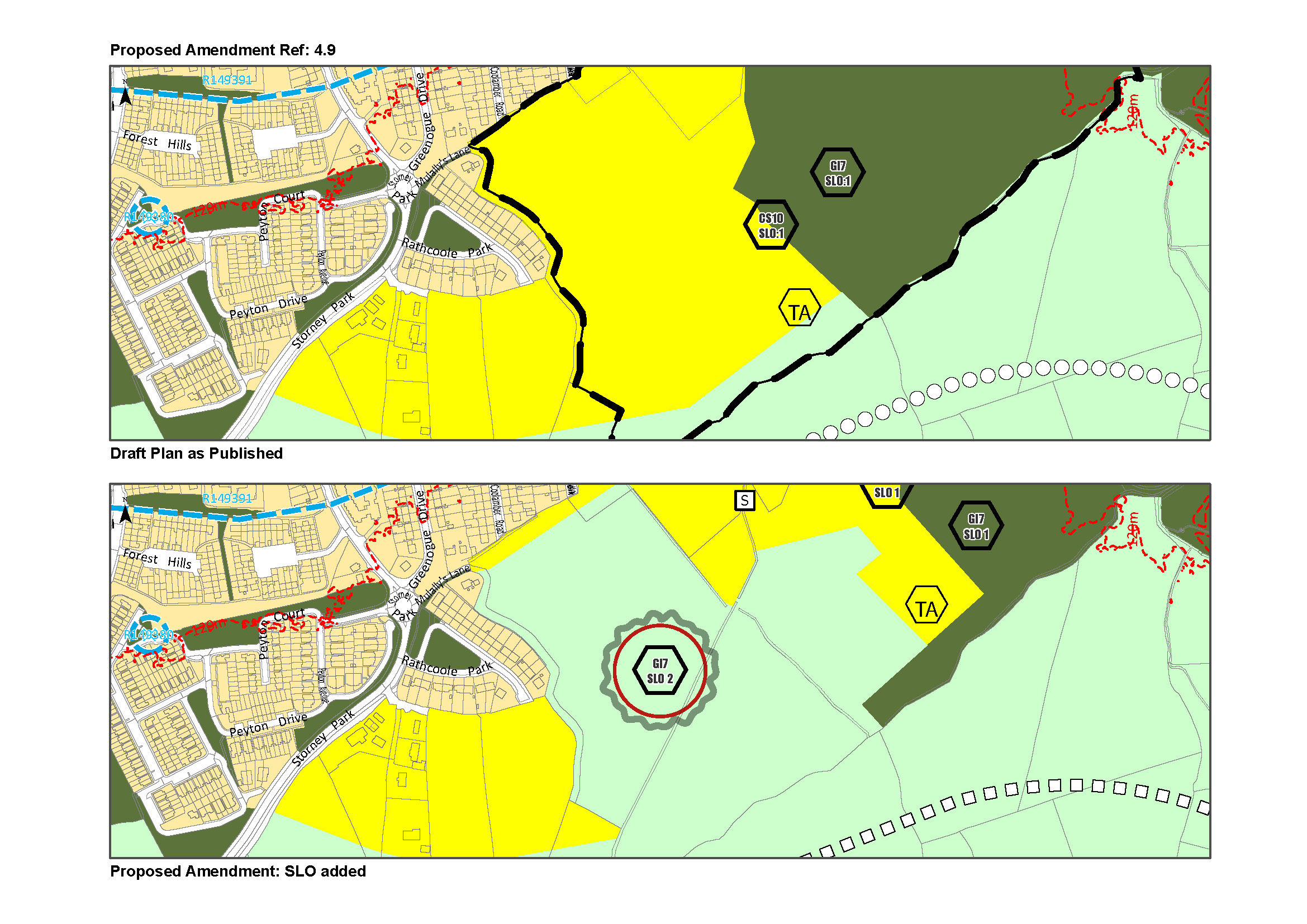
| Chapter/ Section | Section 4.2.5 Landscape, Natural, Cultural and Built Heritage |
| Amendment ref. | Amendment 4.9 |
| Page no. |
153 |
| Policy/Objective No. |
Insert New SLO GI7 SLO2 |
| Text/Policy/Objective Amendment Wording | |
|
Insert new SLO GI7 SLO2: To ensure the adequate protection and augmentation of the identified Alluvial Rathcoole Woodlands within the zoning RU, and in recognising their value as green infrastructure and the potential linkages to Lugg Woods and Slade Valley and other amenity areas, provide for sensitive passive amenity uses which have regard to their Annex 1 status.
|
|
| Chapter/ Section | Section 4.3.2 Strategic Corridor Objectives – Corridor 5: Camac River |
| Amendment ref. | Amendment 4.10 |
| Page no. |
168 |
| Policy/Objective No. |
Addition to Section 4.3.2 – Strategic Corridor 5: Camac River Corridor |
| Text/Policy/Objective Amendment Wording | |
|
Addition to Section 4.3.2 – Strategic Corridor 5: Camac River Corridor – Table 4.1 Insert under Stepping Stones in the first column: Rathcoole Alluvial Woodlands within RU zoning. Add the following objective to the second column:
|
|
| Chapter/ Section | Section 4.3.2 Strategic Corridor Objectives – Corridor 5: Camac River |
| Amendment ref. | Amendment 4.11 |
| Page no. |
168 |
| Policy/Objective No. |
Amend Section |
| Text/Policy/Objective Amendment Wording | |
|
Amend the second Objective (bullet point) in the second column under ‘Objectives associated with the Core Areas / Stepping Stones’ as follows: From: To support the development of a masterplan for the zoned lands at Rathcoole and implement the recommendations. To read: Investigate the potential opportunities to link woodlands at Rathcoole to existing and proposed recreational trails at Lugg Woods and Slade Valley. Insert new objective in the second column under ‘Objectives associated with the Core Areas / Stepping Stones’ as follows: To include woodlands at Rathcoole as part of a wider nature/walking trail from Saggart to Lugg Woods subject to the protection of its biodiversity, wildlife and ecological value which is of primary importance. |
|
| Chapter/ Section |
Appendix 4- Green Infrastructure: Local Objectives and Case Studies |
| Amendment ref. | Amendment 4.12 |
| Page no. |
No page number |
| Policy/Objective No. | L7 – Citywest-Saggart Link |
| Text/Policy/Objective Amendment Wording | |
|
From: Rathcoole Park – Citywest Golf Club – Green space at Cooldown Commons –Coldwater Commons – Green space for development adjacent Fortunestown Luas Stop – Citywest Village Green – Citywest Ave green space – Roadstone Quarry. To: Rathcoole Woodlands - Rathcoole Park – Citywest Golf Club – Green space at Cooldown Commons –Coldwater Commons – Green space for development adjacent Fortunestown Luas Stop – Citywest Village Green – Citywest Ave green space – Roadstone Quarry Insert new Objective: To provide connections between Rathcoole Woodlands and Rathcoole Park as part of a wider walking trail in the area.
|
|
Contents
Observations
Observations
Ref Section 4.2.5 Landscape, Natural, Cultural and Built Heritage Amendment 4.9
I support the need to protect the Woodlands in Rathcoole which are of significance from environmental,...
SUBMISSION 2 Chapter 4, Amendment 4.9
Ref Section 4.2.5 Landscape, Natural, Cultural and Built Heritage Amendment 4.9
I support the need to protect the...
SUBMISSION 2 Chapter 4, Amendment 4.9
Ref Section 4.2.5 Landscape, Natural, Cultural and Built Heritage Amendment 4.9
I support the need to protect the Woodlands in Rathcoole...