I fully support Walking and Cycling and Public transport, and would walk or get a bus or train before i use the car whenever possible. But i feel that these amendments are to to dissuade future...
Amendment No.3
Closed31 Aug, 2026, 00:01 - 29 Sep, 2026, 23:59
Amendment No.3
a). Amend the proposed vehicular bridge over railway to a pedestrian and cycle bridge and
b). To the south of the bridge, provide a Strategic Pedestrian and Cycle Route to the pedestrian and cycle bridge.
c). To the north of the bridge, remove Link Street from the North Link Street to bridge and provide a Strategic Pedestrian and Cycle Route from North Link Street to the pedestrian and cycle bridge
d). Amend bridge types in Table 2.2.2 and remove the reference to the vehicular bridge in the phasing section (Table 4.2).
It is proposed to amend the vehicular bridge over the railway to a pedestrian and cycle bridge, alongside updating the adjoining street from a Link Street to a Local Street. This amendment is intended to promote sustainable and active travel within the SDZ while maintaining strong connectivity and permeability between the northern and southern areas of the railway line. The revised bridge alignment is highlighted in red on the map that follows this section.
To assess the potential impacts of this change, South Dublin County Council engaged Systra to model the effects of removing vehicular access from the bridge. The Systra Modelling Report concludes that while traffic previously using the bridge will reroute via Fonthill Road North and Lynch’s Lane, this redistribution remains manageable and does not cause significant operational issues across the wider road network. The study identified four key junctions—Junctions 7, 8, 10, and 11—that required further assessment due to increased traffic flows.
Of these, Junction 7 experiences minor congestion increases in the AM peak at Grange Castle Road northbound and the Access Road eastbound, but it remains within acceptable operational limits with no mitigation required. Junction 8, however, faces increased capacity pressures, particularly at the northbound right turn at Fonthill Road North, which shows a 90% increase in Degree of Saturation (DOS) in the AM peak, along with a 60.4% increase in the PM peak. The western approach of the junction also experiences a 42.4% increase in traffic volume. The report suggests that potential widening of the carriageway at the eastern and western arms to accommodate additional turning lanes could be a feasible mitigation measure. Meanwhile, Junctions 10 and 11 operate well within capacity, and no changes are required.
Overall, the modelling confirms that removing vehicular access from the bridge does not cause major operational issues, aside from localised impacts at Junction 8, where further monitoring and minor mitigation may be necessary. The proposed amendment aligns with the sustainable mobility objectives of the SDZ, enhancing pedestrian and cyclist permeability while maintaining a well-functioning road network. Additionally, future transport policy interventions and investments in sustainable modes may further reduce car dependency, mitigating any residual impacts. These findings provide strong technical support for Amendment No. 3, reinforcing its alignment with the SDZ’s strategic objectives and national transport policies.
The Planning Scheme previously included a green link in association with the proposed vehicular bridge in this location. This green link was required to support placemaking and permeability associated with vehicular infrastructure. However, as the vehicular bridge is now being removed in favour of a pedestrian and cycle bridge, the green link is no longer required. This amendment reflects the revised movement function of the bridge and surrounding streets and ensures alignment with the SDZ’s emphasis on sustainable and active travel modes.
For full details of the modelling results, please refer to Appendix 5.
The proposed amendments to the scheme detail the change in bridge type in the relevant tables and remove the reference to the vehicular bridge in the phasing section.
| Amendment Ref. No. 3 | |
| Section Reference | Page Reference (2019 Planning Scheme) |
| Figure 2.2.7, Table 2.2.2, Table 4.2 | 31, 32, 133 |
Update Figure 2.2.7 Overall Movement concept on Page 31 to indicate a colour change on the map and in the legend from red which indicates ‘Proposed Link Route’ to orange which is indicated on the map as a ‘Proposed Local Street’.
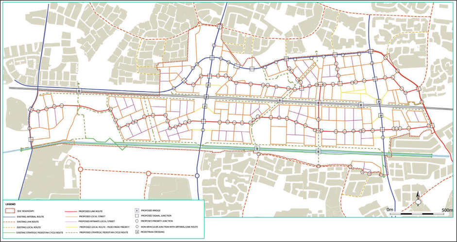
Figure 1: Overall Movement Concept
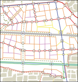
Figure 2: Propose to amend the proposed vehicular bridge over railway to a pedestrian/cycle bridge
Edit table 2.2.2 | Canal and Rail Bridges
| Bridge Type | Number |
| Canal Overbridge – pedestrian & cyclist | X3 (including 1 existing) |
| Canal Overbridge – vehicular, public transport, pedestrian & cyclist | X3 existing |
| Rail Overbridge – pedestrian & cyclist | |
| Rail Overbridge – vehicular, public transport, pedestrian and cyclist |
X3 existing |
Edit Table 4.2 | Infrastructure required to be linked to the delivery of residential development and phased in accordance with the construction of residential units
| 1. | Surface Water Management Plan measures* |
| 2. | Undergrounding of the 220kv Power Lines |
| 3. | Griffeen Valley Park Extension (includes upgrade of existing pedestrian bridge over railway to Green Bridge) |
| 4. | Na Cluainte (North and South) |
| 5. | Schools Sites |
| 6. | Community Buildings (Provision of) |
| 7. | District Park Hub (Provision of) |
| 8. | Health Centre |
| 9. | Childcare Facilities |
| 10. | Retail floorspace |
| 11. | Fire Station site |
| 12. | Main Link Streets within scheme (See Section 2.2.4) |
| 13. | Major Signal Junctions (new and upgrades between combinations of Arterial Streets and Link Streets) ** |
| New Pedestrian & Cycle Canal overbridges | |
| New Pedestrian & Cycle Railway overbridges | |
| Upgrade & realignment of R120 Lock Road | |
| Opening of Railway Station at Kishoge |
Contents
Observations
Observations
Amend the proposed vehicular bridge over railway to a pedestrian and cycle bridge
The proposal to construct a footbridge rather than a bridge suitable for vehicles is a significant cause for concern.Downgrading it to a footbridge would fail to provide the road connectivity...
Retain railway vehicular bridge until DART+ South West is delivered
I am the owner [Personal Information Redacted], Seven Mills, Clonburris. I object to Amendment No. 3.Seven Mills has only two vehicle access points, and these already queue at peak and school times....
Objecting to the bridge amendments
I, a Parkleigh, Seven Mills Clonburris resident, object to this change as I believe it will cause more traffic congestion on the other two junctions and will restrict our connections.Completely...
Parking Provision, Public Realm Waste Infrastructure, and Public Transport Phasing
I am a resident of the Clonburris SDZ area [Personal Information Redacted] and wish to make a submission on the Proposed Material Amendment. My comments are based on lived experience of the first...