Dear Sir/Madam,The Lockhouse Way Residents’ Association represents residents of Lockhouse Way, Seven Mills, Clonburris, and is registered with the South Dublin County Public Participation Network (...
Amendment No.18
Closed31 Aug, 2026, 00:01 - 29 Sep, 2026, 23:59
Amendment No.18: Relocate unused residential units from southern to northern development areas
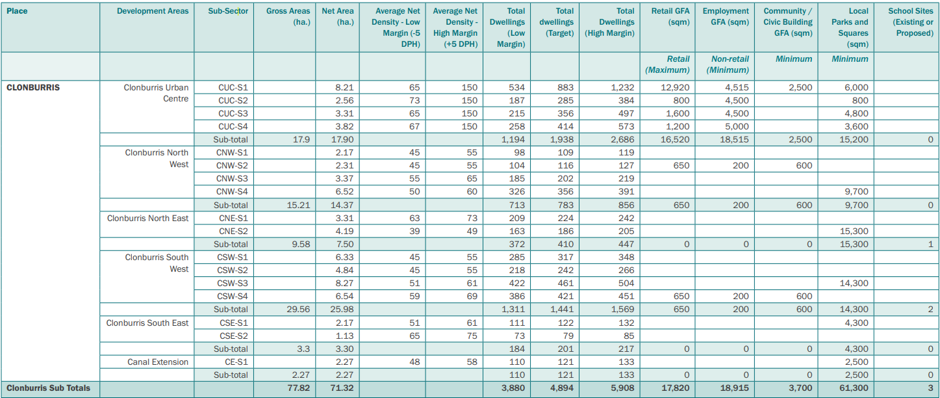
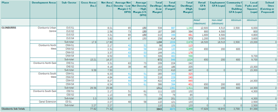
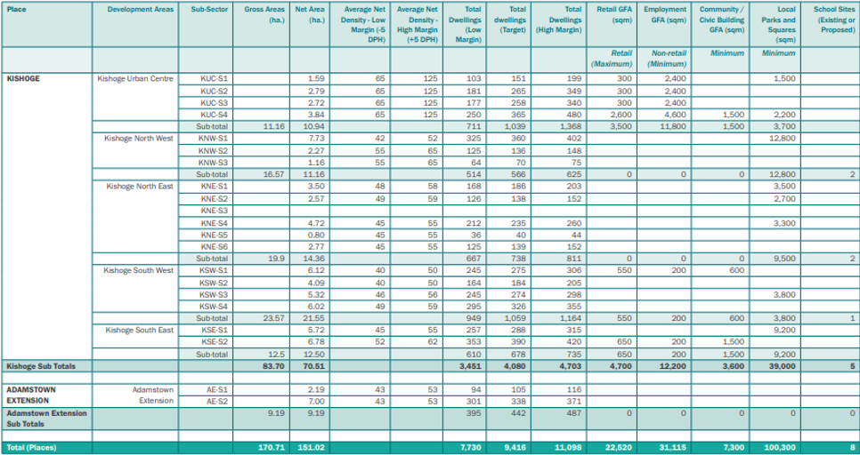
It is proposed to amend Table 2.13.1 of the Clonburris SDZ Planning Scheme (pages 95 & 96) and replicate in Section 2 and 3 tables (Table 2.1.5, Table 2.1.8 and Table 3.1.1-3.1.12 – not illustrated) to reflect the reallocation of 230 unused residential units from southern to northern development areas. These units arise from underutilised capacity in the southern SDZ lands, including sites that are either permitted or currently within the planning system.
A detailed assessment confirms that this under delivery occurs across several southern development areas. The proposed reallocation is intended to optimise housing delivery in the northern areas, where compact growth principles, the new Compact Guidelines (see amendment no.1), infrastructure availability, and planning objectives support increased residential density. The amendment will update maximum unit allocations accordingly while maintaining the overall SDZ unit maximum. This approach aligns with the National Planning Framework and SDZ principles, improves infrastructure efficiency, avoids unnecessary investment in lower-demand areas, and advances national and local housing delivery targets.
Tables 1 and 2 below set out the full breakdown of the proposed unit reallocation. Table 1 details the southern development areas with underutilised capacity and the corresponding variance. Table 2 outlines the proposed adjustments to unit allocations in the receiving northern development areas, demonstrating where capacity exists and how the redistributed units will be absorbed.
Southern Lands – Unused Units (Total: 230)
| SDZ Ref Development Area | SDZ Max | Proposed/ permitted Units | Unused Units |
| CUC-S3 | 497 | 481 | -16 |
| CSW-S1 | 348 | 325 | -23 |
| CSW-S2 | 266 | 240 | -26 |
| CSW-S3 | 504 | 445 | -59 |
| CSW-S4 | 451 | 401 | -50 |
| KUC-S4 | 480 | 495 | +15 |
| KSE-S1 | 315 | 279 | -36 |
| KSE-S2 | 420 | 385 | -35 |
| Total | 3281 | 3051 | -230 |
Table 1: Southern Lands – Unused Units (Total: 230)
| SDZ Ref Development Area | Previous Max | Proposed Max | Variance |
| CUC-S1 | 1232 | 1240 | 8 |
| CNW-S1 | 119 | 113 | -6 |
| CNW-S2 | 127 | 135 | 8 |
| CNW-S3 | 219 | 178 | -41 |
| CNW-S4 | 391 | 598 | 207 |
| KNE-S4 | 260 | 260 | 0 |
| KNE-S5 | 44 | 16 | -28 |
| KNE-S6 | 152 | 234 | 82 |
| Total | 2544 | 2778 | 230 |
Table 2: Northern Lands – Revised Maximum Unit Allocations (Total Increase: 230)
This amendment represents a balanced and policy-aligned reallocation of residential units within the SDZ, optimising housing delivery while remaining within the overall unit cap. The redistribution supports national and local compact growth objectives, better aligns residential densities with existing and planned infrastructure, and reflects the current development realities on the ground. In particular, the reduction in development capacity at KNE-S5, arising from the identification of this sub-sector as a preferred location for a new fire station, necessitates a shift in unit delivery to neighbouring development areas such as KNE-S6 and CNW-S4. Similar to KNE-S3 (school site), residential development is no longer feasible at KNE-S5, however, the site area is retained in the table for completeness, and a reduction of 28 units is shown to reflect this reallocation. These adjustments ensure that land previously allocated for residential use is now more appropriately used for essential infrastructure, while still maintaining the overall housing delivery potential of the SDZ. This strategic and place-based approach enhances the resilience and deliverability of the Clonburris Planning Scheme and reflects the SDZ’s commitment to sustainable, infrastructure-led development.
| Amendment Ref. No. 18 | |
| Section Reference | Page Reference (2019 Planning Scheme) |
| Table 2.13.1 | 95 & 96 |
Amend figures in relevant columns in Table 2.13.1 to align with Tables 1 & 2 detailed within this amendment. Shown are existing tables within the planning scheme, and the proposed changes as follows indicated by different colours:
- Green indicates the increase of reallocated units into development areas.
- Red indicates the decrease of units in development areas.
- Blue indicates changes in density figures and total dwelling targets which come from the redistribution of units.
Clonburris table within current Planning Scheme:
Proposed updated Clonburris table on the basis of Amendment 18:
Kishoge Table within current Planning Scheme:
Proposed updated Kishoge table on the basis of Amendment 18: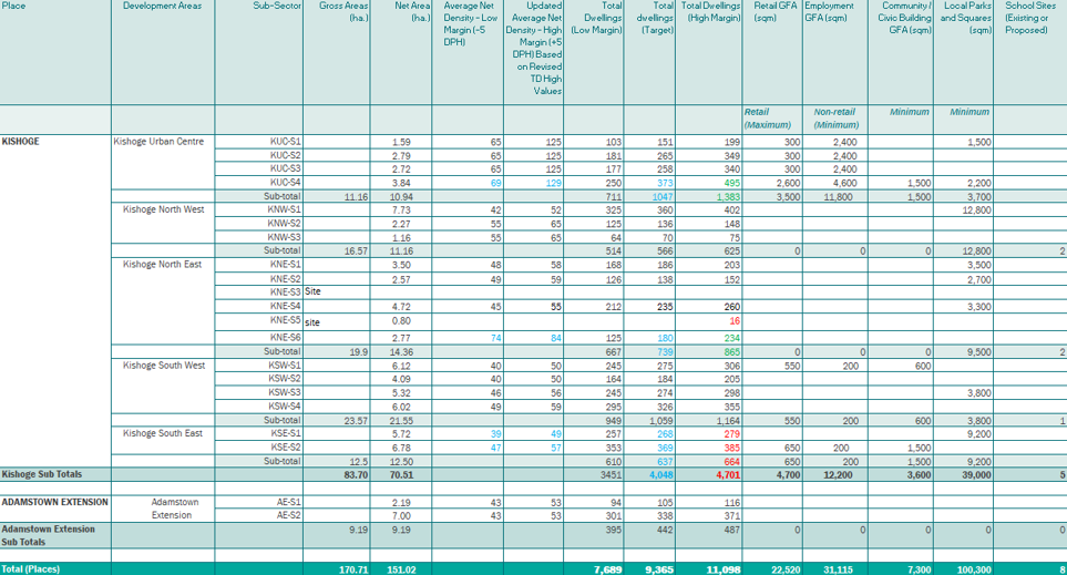
Contents
Observations
Observations
Proposed Material Amendments to the Clonburris SDZ Planning Scheme 2019
Proposed Material Amendments to the Clonburris SDZ Planning Scheme 201
I am a resident of [Personal Information Redacted]. I make this submission on the Proposed Material Amendment to the Clonburris SDZ Planning Scheme 2019 (amendments 3, 4, 8, 9 and 18). I support...