The density range proposed for the ninth lock development is excessive (city level density). Clondalkin is located at the outer edge of the suburbs of the Dublin Settlement. This proposed development is not in line with Sustainable and Compact Settlements Guidelines for Local Authorities. The proposed development is not included in any targets for the area in the SDCC Development Plan. Clondalkin Village has yet to absorb the impact of the largest Strategic Development Zone in the country as well as large development at Kilcarbery. Both of these sites are significant for Clondalkin, they are also not represented in the figures included for social housing (LPF, p.8). This is misleading and should be revised to reflect the actual development of social housing units in recent years. A table should be included in the LPF document to show the figures of all housing units completed and under construction in the Clondalkin area with a breakdown of tenure type.
All developments within the LPF village area in recent years have been unavailable for sale. The ninth lock proposal looks to continue the trend of building apartments unavailable for home ownership and not reflecting the housing needs of the area. A meaningful figure to include from the Census 2022 would be the number of adults aged 30+ living in their family home in the wider LEA. Any development in the area should state at the outset what type of tenure will be available (as is required by planning law). The apartments under development at Watery Lane is an example of a site developed during the lifetime of the current Development Plan where the aspirations of the Plan have not been implemented, and nearly all planning conditions applied to the permission were quashed.
With a 0.64% population increase and the largest SDZ in the country, the ninth lock development at the proposed density is excessive and the benefit to the area is not illustrated. According to the HP Deprivation Index, a number of areas within the LPF have declined between the last two Census years and are now classified as below average or disadvantaged. There needs to be an analysis to identify the reasons for these declines and to identify how the LPF will positively influence the prosperity of the area including in relation to tenure type.
The SEA developed for the LPF uses the Corine 2018 data to scope habitats in the area. The National Land Cover Map would provide more accurate detail. An explanation for not including the most detailed habitat dataset available as part of the analysis should be provided. There has been a net loss of trees and green space in the area and quantification of this should be provided in the LPF and monitored.
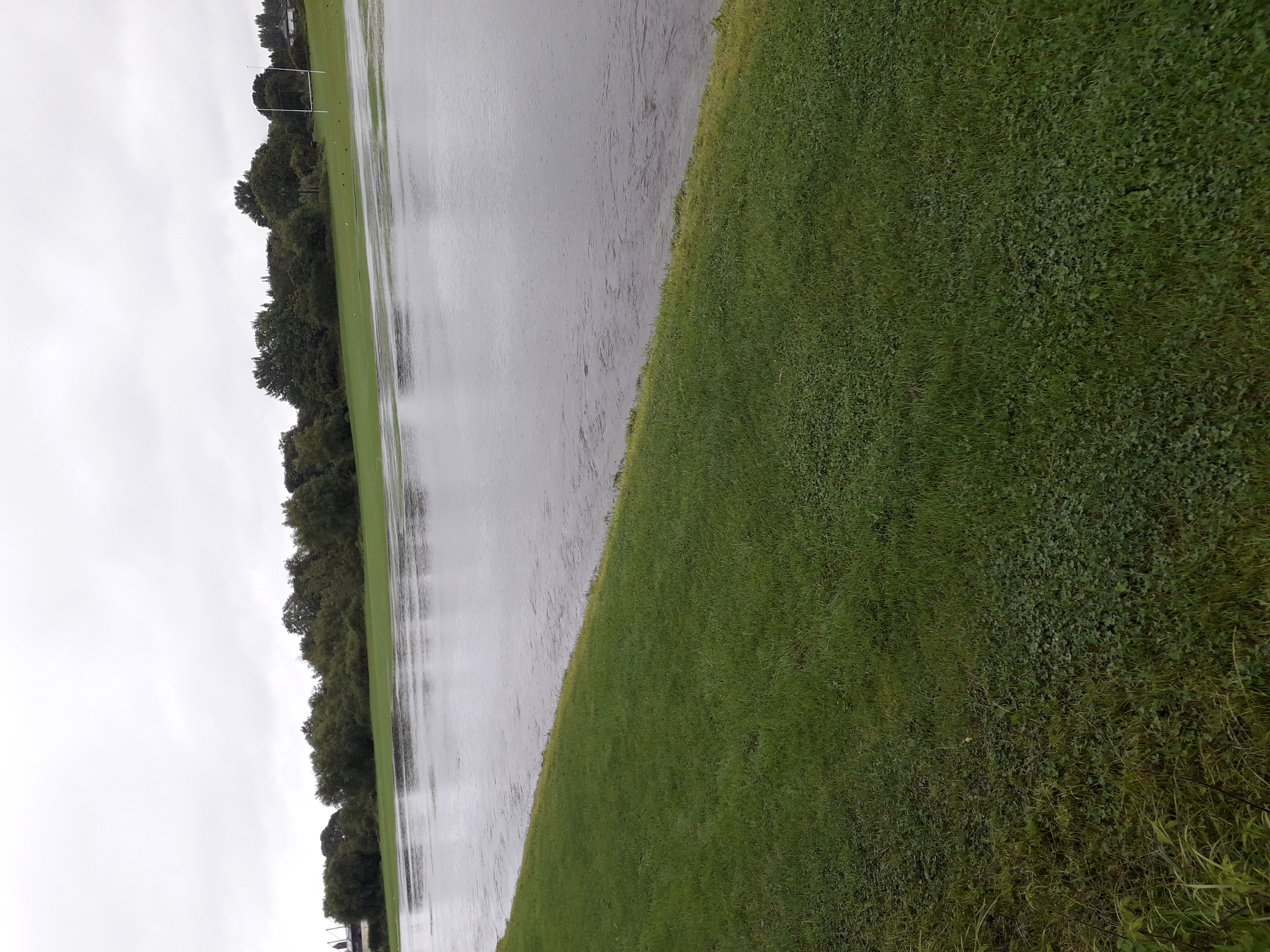
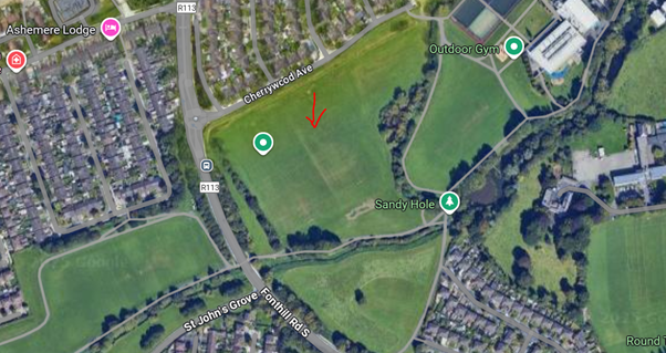
There is no mention of the Nature Restoration Law/Plan which aims to halt the loss of green space in built up areas to mitigate against climate change impacts including increased temperatures and flooding as well as biodiversity loss. I’ve included a photo and location of flooding at Clondalkin Park during summer 2025, this is a new flooding extent in the LPF area (Figures 2 &3). The data used in the associated flood assessment for this LPF is out of date and does not account for recent development and increased impermeable surfaces in the area. The ninth lock site is also identified as an Opportunity Site in this assessment. The assessment highlighted the poor ecological condition of the Camac in the LPF area. Recent developments (built during the current Development Plan) near Clondalkin Park have also not adhered to the River Basin Management Plan guidelines. The proposed development at ninth lock is on flood risk land and will increase flood risk within the area and the sub-catchment. This will further disrupt hydraulic connections and deteriorate the ecological condition of the Camac River which is failing to meet EU WFD objectives. The Camac is home to the White-clawed Crayfish, a protected species under the Wildlife Acts. It is difficult to buy in to the climate change actions proposed as part of the decarbonisation zone plans when this type of development is being considered, reducing the resilience of nature and the nature based protection that healthy ecosystems provide. A lower density development with a larger percentage of the land used for quality green space would be more beneficial for the prosperity and resilience of Clondalkin and align with the obligations being set out in the Nature Restoration Plan in terms of access to quality green space and resilience to the effects of climate change and biodiversity loss.
At the Seven Mills development, established hedgerows where removed. I was informed by the contractors that this was due to the shape of the zoned land parcel and the orientation guidelines for residential units. This is a serious flaw in the zoning of residential land. A more considered approach with qualified ecologists alongside planners should be used to ensure developments can be designed to retain important established habitats. Any ability to adjust the zonings where the shape of the parcel allows for retention of hedgerows should be evaluated (possibly through another ‘Variation’).
Can the Local Authority provide detail on how much green space has been lost in the LPF area throughout the duration of the current Development Plan? Can the Local Authority provide detail on how they will implement the Nature Restoration Plan? What will the Green Space Ratio be for residents of the area?
Unfortunately, the use of ebikes and escooters to facilitate anti-social behaviour in this area needs to be recognised when proposing linking areas for walkability. Currently, footpaths are unsafe for pedestrians and walking to the local shops is now less safe than driving. This a real and serious risk for residents in this area. The anti-social behaviour issues in the area have to be considered throughout the framework and decarbonisation proposals. This is as much part of placemaking as retaining an old wall.
Can a definition of healthy placemaking be provided?