An Taisce submission attached.
Alterations to Chapter 2: City Edge SURF Strategy
Dúnta24 Iúil, 2026, 17:55 - 21 Lún, 2026, 23:59
|
Material Alteration Reference: MA2.1 |
|
|
Amendment No. 1 |
|
|
Location in SURF: Section 2.3.2 |
Page No.(s): 28 |
|
Amendment to Section 2.3.2 (P.28) to include the following text in the first Key Principle for Land use: From: To provide for new mixed use residential and employment communities, through sustainable higher density urban forms, served by high-quality public transport and active travel links. To: To provide for new mixed use residential and employment communities, through sustainable higher density urban forms, served by high-quality public transport and active travel links with density increasing in accordance with public transport accessibility. |
|
|
Material Alteration Reference: MA2.2 |
|
|
Amendment No. 2 |
|
|
Location in SURF: Section 2.3.3 |
Page No.(s): 29 |
|
Amend definition of ‘Employment Led Mixed Use’ in box headed ‘SURF Land Use Mix Categories’ as follows: From: Areas with a greater focus on employment uses, mixed with residential. To: Areas with a greater focus on employment uses, including urban industry and urban workspaces, mixed with residential. Some scope for convenience retail. |
|
|
Material Alteration Reference: MA2.3 |
|
|
Amendment No. 3 |
|
|
Location in SURF: Section 2.3.3 |
Page No.(s): 29 |
|
Amend definition of ‘Urban Industry Led’ in box headed ‘SURF Land Use Mix Categories’ as follows: From: Areas suitable for lower density employment uses, including industrial employment uses that can co-locate with other employment uses. Limited scope for residential. To:
|
|
|
Material Alteration Reference: MA2.4 |
|
|
Amendment No. 4 |
|
|
Location in SURF: Section 2.3.3 |
Page No.(s): 29 |
|
Amend definition of ‘Industry’ in box headed ‘SURF Land Use Mix Categories’ as follows: From: Areas with a focus on lower density employment uses, including industrial employment uses that suit proximity to the national road network. Some scope for convenience retail. No scope for residential. To:
|
|
|
Material Alteration Reference: MA2.5 |
|
|
Amendment No. 5 |
|
|
Location in SURF: Section 2.3.3 |
Page No.(s): 29 |
|
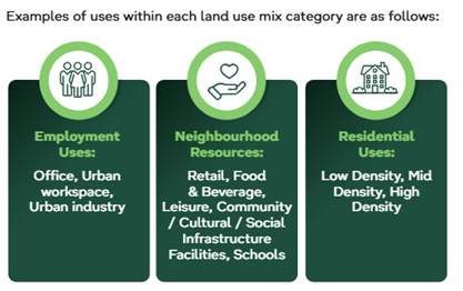
Amend the below infographic as follows:
From: Examples of uses within each land use mix category are as follows: To:
Examples of
From: Employment Uses: To:
Employment
From: Office, Urban Workspace, Urban Industry To: Office, Urban Workspace, Urban Industry, Industry.
From Neighbourhood Resources To
From: Residential Uses: To:
Residential |
|
|
Material Alteration Reference: MA2.6 |
|
|
Amendment No. 6 |
|
|
Location in SURF: Section 2.3.3 |
Page No.(s): 31 |
|
Urban Industry Change from:
To: Urban industrial buildings generally accommodate manufacturing, production, and high-value economic activities located within or close to mixed-use urban areas. Unlike traditional industry, it often emphasizes modern, flexible, and sustainable production, that integrates well in an urban environment. Urban industrial type uses may be accommodated in industrial areas as the latter densify over time. |
|
|
Material Alteration Reference: MA2.7 |
|
|
Amendment No. 7 |
|
|
Location in SURF: Table 2 |
Page No.(s): 34 |
|
Include the following note under Table 2 PDA summary table: Note: While the identified PDAs have the capacity to deliver in excess of 9,084 units the development of these areas will be subject to monitoring of population and housing targets in accordance with the South Dublin County Development Plan Core Strategy and Policy CS3 which seeks to promote and facilitate housing and population growth in accordance with the overarching Core Strategy to meet the needs of current and future citizens of South Dublin County. |
|
|
Material Alteration Reference: MA2.8 |
|
|
Amendment No. 8 |
|
|
Location in SURF: Figure 5 |
Page No.(s): 42 |
|
Amend Figure 5 to make street names more prominent, to improve the differentiation between colours used in the legend, and to correctly illustrate the classification of roads. Refer to Book of Maps. |
|
|
Material Alteration Reference: MA2.9 |
|
|
Amendment No. 9 |
|
|
Location in SURF: Figure 6 |
Page No.(s): 44 |
|
Amend Figure 6 to make street names more prominent and to improve the differentiation between colours used in the legend. Refer to Book of Maps. |
|
|
Material Alteration Reference: MA2.10 |
|
|
Amendment No. 10 |
|
|
Location in SURF: Figure 7 |
Page No.(s): 45 |
|
Amendment to Figure 7 to depict a Mobility Hub Type 3 at the intersection of Oak Road and Naas Road and to indicate the proposed DART SW+. Refer to Book of Maps. |
|
|
Material Alteration Reference: MA2.11 |
|
|
Amendment No. 11 |
|
|
Location in SURF: Section 2.5.4 |
Page No.(s): 46 |
|
Amendment to Section “Other Public Transport Proposals” (p.46) as follows: From: The City Edge Strategic Framework (2022) proposed two orbital public transport routes that are not contained within the GDA Transport Strategy. To:
The City Edge Strategic Framework (2022) proposed two orbital public transport routes that are |
|
|
Material Alteration Reference: MA2.12 |
|
|
Amendment No. 12 |
|
|
Location in SURF: Policy MOV2 |
Page No.(s): 48 |
|
Amendment to Policy MOV2: Public Transport (p.48) as follows: From: To continue to work with the NTA and TII to facilitate the delivery of public transport projects with the goal of providing sufficient capacity in a phased manner to support development of the City Edge Priority Development Areas. To: To continue to work with the NTA and TII to facilitate the delivery of public transport projects, and to ensure alignment with evolving national and regional transport strategies, with the goal of providing sufficient capacity in a phased manner to support development of the City Edge Priority Development Areas. |
|
|
Material Alteration Reference: MA2.13 |
|
|
Amendment No. 13 |
|
|
Location in SURF: Policy MOV2 Objective 2 |
Page No.(s): 48 |
|
Amendment to MOV2 Objective 2 as follows: From: To engage with the NTA and TII regarding implementation of BusConnects schemes within the City Edge area including agreement on public realm design including provision for pedestrians and cyclists, greening and SuDS, and design of the cycle bridge at the Naas Road/Long Mile Road/Nangor Road Junction To:
To engage with the NTA and TII |
|
|
Material Alteration Reference: MA2.14 |
|
|
Amendment No. 14 |
|
|
Location in SURF: Table 3 |
Page No.(s): 51 |
|
Amendment to Table 3: Mobility Hub Components and Realm Improvements by removing the word “Tram”. |
|
|
Material Alteration Reference: MA2.15 |
|
|
Amendment No. 15 |
|
|
Location in SURF: Figure 8 |
Page No.(s): 53 |
|
Amendment to Figure 8 to depict a Mobility Hub Type 3 at the intersection of Oak Road and Naas Road and to indicate the proposed DART +SW. Refer to Book of Maps. |
|
|
Material Alteration Reference: MA2.16 |
|
|
Amendment No. 16 |
|
|
Location in SURF: Policy MOV4 Objective 1 |
Page No.(s): 54 |
|
An amendment to MOV4 Objective 1 as follows: From: To require the provision of resident, employee and visitor cycle parking on site, unless the developer / applicant can demonstrate that cycle parking can be provided for in whole or in part in a shared parking building. To:
To require the provision of resident, employee and visitor cycle parking on site. |
|
|
Material Alteration Reference: MA2.17 |
|
|
Amendment No. 17 |
|
|
Location in SURF: Section 2.5.7 |
Page No.(s): 54 |
|
Amendment to the first bullet point in the green box headed “Implementation of Cycle Parking” to include the following text: From: Cycle Parking will be provided in line with the CDP standard, with reference to the Planning Design Standards for Apartments, Guidelines for Planning Authorities, 2025 (or any superseding document). To: Cycle Parking will be provided in line with the CDP standard, with reference to the Planning Design Standards for Apartments, Guidelines for Planning Authorities, 2025, in accordance with the Cycle Design Manual, or any superseding documents. |
|
|
Material Alteration Reference: MA2.18 |
|
|
Amendment No. 18 |
|
|
Location in SURF: Section 2.5.7 |
Page No.(s): 54 |
|
Removal of the second bullet point in the green box headed “Implementation of Cycle Parking” as follows: From: Where there is existing capacity in a nearby shared parking building, a lower level may be provided on site, if it can be demonstrated that the required standard is still met. To:
|
|
|
Material Alteration Reference: MA2.19 |
|
|
Amendment No. 19 |
|
|
Location in SURF: Section 2.5.7 |
Page No.(s): 54 |
|
Amendment to the third bullet point in the green box headed “Implementation of Cycle Parking” to include the following text: From: Parking facilities will include provision for personal mobility devices such as e-scooters. To: Parking facilities will include provision for personal mobility devices such as e-scooters and a range of cycle types including cargo and accessible bikes. |
|
|
Material Alteration Reference: MA2.20 |
|
|
Amendment No. 20 |
|
|
Location in SURF: Section 2.5.7.2 |
Page No.(s): 54 - 55 |
|
Minor amendment to Section 2.5.7.2 Car Parking to include the following text: From: An alternative parking model is proposed for City Edge which facilitates the parking needs of residents (and other users) in collective multi-use parking buildings rather than individual parking areas situated under each apartment development. These buildings are referred to as ‘shared parking buildings’. They will be designed with future re-purposing in mind, when enhanced public transport is delivered, reducing the need for private transport. To: An alternative parking model is proposed for City Edge which facilitates the parking needs of residents (and other users) in collective multi-use parking buildings rather than individual parking areas situated under each apartment development. These buildings are referred to as ‘shared parking buildings’. They will be designed with future re-purposing in mind (provided that there is no net loss of cycle parking facilities), when enhanced public transport is delivered, reducing the need for private transport. |
|
|
Material Alteration Reference: MA2.21 |
|
|
Amendment No. 21 |
|
|
Location in SURF: Section 2.6.1, 2nd Para, Line 1 |
Page No.(s): 63 |
|
Delete reference to 35m in first line of second paragraph on page 63 as follows: From: In the Greenhills PDA, taller elements of up to 35m are concentrated along the major route, Calmount Road and the proposed Calmount local centre location. To:
In the Greenhills PDA, taller elements |
|
|
Material Alteration Reference: MA2.22 |
|
|
Amendment No. 22 |
|
|
Location in SURF: Section 2.6.2 |
Page No.(s): 63 |
|
Amend the heading and text within Section 2.6.2 of the SURF as follows: From: 2.6.2 PLOT RATIO The Sustainable Residential Development and Compact Settlements Guidelines for Planning Authorities define plot ratio as follows: ‘Expresses the proportionate relationship between the area of a site and the total gross floor area of a building(s). It is a measure of the intensity of land use and is calculated by dividing the gross floor area of a building(s) (sum of floorspace within the external walls of the building) by the site area.’ The Guidelines state that dwellings per hectare (dph) ‘will continue to be the primary measure for residential density’ but that in the case of mixed-use, commercial and employment areas, ‘plot ratio and site coverage standards may also need to be considered in order to manage the scale and massing of development’. To: 2.6.2 DENSITY and PLOT RATIO The provisions of the County Development Plan in particular Variation no. 2 to the County Development Plan table 5.1, set out appropriate density ranges in line with the Sustainable Residential Development and Compact Settlements - Guidelines for Planning Authorities (2024). The lands within the City Edge SURF are identified as being located within the category ‘City – Urban Neighbourhoods’ where a density range of 50-250 dwellings per hectare will generally be applied. As per the provisions of the Guidelines, further refinement of densities will be carried out on a plan led basis based on considerations of centrality and accessibility to services and public transport, character, amenity and the natural environment. The provision of transport interchanges, the proposed DART + South-West, BusConnects and future potential LUAS lines will support a compact form of development. As such there is a presumption that net residential density in the range of 200-250 dph is achievable at highly accessible locations within the PDAs. The Sustainable Residential Development and Compact Settlements Guidelines for Planning Authorities define plot ratio as follows: ‘Expresses the proportionate relationship between the area of a site and the total gross floor area of a building(s). It is a measure of the intensity of land use and is calculated by dividing the gross floor area of a building(s) (sum of floorspace within the external walls of the building) by the site area.’ The Guidelines state that dwellings per hectare (dph) ‘will continue to be the primary measure for residential density’ but that in the case of mixed-use, commercial and employment areas, ‘plot ratio and site coverage standards may also need to be considered in order to manage the scale and massing of development’. |
|
|
Material Alteration Reference: MA2.23 |
|
|
Amendment No. 23 |
|
|
Location in SURF: Figure 9 |
Page No.(s): 64 |
Refer to Book of Maps. |
|
|
Material Alteration Reference: MA2.24 |
|
|
Amendment No. 24 |
|
|
Location in SURF: Policy HOU1 |
Page No.(s): 69 |
|
Add a new objective to Policy HOU1 ‘Residential Development in City Edge’ as follows: To ensure that all social housing units delivered through Part 5 agreements within the City Edge area are fully integrated within residential developments and that residents have equal access to all communal areas, facilities, amenities, and shared spaces provided as part of the development. |
|
|
Material Alteration Reference: MA2.25 |
|
|
Amendment No. 25 |
|
|
Location in SURF: Policy SCCA1 Objective 1 |
Page No.(s): 71 |
|
Amend Policy SCCA1 Objective 1 as follows: From: To continue to engage with the Department of Education and Youth regarding schools need, while actively monitoring planning applications, construction activity and population growth in the area, and taking into account latent capacity in existing schools in the wider area. To:
To continue to engage with the Department of Education and Youth regarding schools need, while actively monitoring planning applications, construction activity and population growth in the area, |
|
|
Material Alteration Reference: MA2.26 |
|
|
Amendment No. 26 |
|
|
Location in SURF: Policy SCCA1 |
Page No.(s): 71 |
|
Add new objective to Policy SCCA1 ‘Schools’ as follows: To engage with the Higher Education Authority (HEA) and the Department of Further and Higher Education, Research, Innovation and Science to support, promote and facilitate the location of third level education facilities within City Edge. |
|
|
Material Alteration Reference: MA2.27 |
|
|
Amendment No. 27 |
|
|
Location in SURF: Policy SCCA1 |
Page No.(s): 71 |
|
Add a new objective to Policy SCCA1 ‘Schools’ as follows: All proposed school sites shall be connected by direct, safe and universally accessible pedestrian and cycle routes linking surrounding residential areas, public transport, parks and community facilities. A Safe Routes to School Strategy shall be submitted as part of the first planning application relating to each school site, demonstrating compliance with Universal Design principles, active travel objectives and the delivery of the required infrastructure in tandem with, or in advance of, the occupation of the school and associated residential development. |
|
|
Material Alteration Reference: MA2.28 |
|
|
Amendment No. 28 |
|
|
Location in SURF: Section 2.10, 4th Para, 2nd Sentence. |
Page No.(s): 75 |
|
Amend the following sentences: From: While retail will be channelled into local centre areas, retail warehousing will be more suited to areas identified for other land use types such as Employment-Led Mixed Use or Urban Industry that have both good public transport and road connectivity. The latter recognises the need to transport bulky goods using private transport. To:
While retail will be channelled into local centre areas, retail warehousing will be more suited to areas identified for other land use types such as |
|
|
Material Alteration Reference: MA2.29 |
|
|
Amendment No. 29 |
|
|
Location in SURF: Section 2.11 |
Page No.(s): 80 |
|
Amend text in green box as follows:
|
|
|
Material Alteration Reference: MA2.30 |
|
|
Amendment No. 30 |
|
|
Location in SURF: Policy EMP1 |
Page No.(s): 81 |
|
Add new objective to Policy EMP1 as follows: ‘To support existing enterprise operations and new enterprise activities, through the provision of flexible employment space and encouraging co-location with other uses including community facilities.’ |
|
|
Material Alteration Reference: MA2.31 |
|
|
Amendment No. 31 |
|
|
Location in SURF: Policy EMP1 Objective 2 |
Page No.(s): 81 |
|
Add additional wording to objective as follows: From: To support existing employment uses and diversification into new and emerging sectors within the City Edge area. To:
To support existing employment uses |
|
|
Material Alteration Reference: MA2.32 |
|
|
Amendment No. 32 |
|
|
Location in SURF: Policy EMP1 Objective 5 |
Page No.(s): 82 |
|
Amend the objective as follows: From: Locations identified for Employment-Led Mixed Use within areas zoned ‘Regen’ in the City Edge area shall consist of lighter uses, where the potential for noise pollution, air pollution or other nuisance from industrial uses will not exceed acceptable environmental standards, in the context of the potential for residential and other sensitive uses in close proximity. To:
Locations identified for Employment-Led Mixed Use within areas zoned ‘Regen’ in the City Edge area shall consist of lighter uses, including Office, Urban Industry and Urban Workspaces where the potential for noise pollution, air pollution or other nuisance |
|
|
Material Alteration Reference: MA2.33 |
|
|
Amendment No. 33 |
|
|
Location in SURF: Policy EMP1 Objective 6 |
Page No.(s): 82 |
|
Amend the objective as follows: From: Locations identified for Urban Industry within areas zoned ‘EE’ in the City Edge area shall consist of uses such as light and heavy industry, manufacturing (including advanced manufacturing), warehousing, distribution and production. These uses will generally be considered acceptable, subject to appropriate environmental safeguards in accordance with the criteria set out in Chapter 12 ‘Implementation’ of the Development Plan. Development shall provide appropriate buffers / safeguards to adjoining areas with more sensitive uses such as residential. To:
‘Locations identified for |
|
|
Material Alteration Reference: MA2.34 |
|
|
Amendment No. 34 |
|
|
Location in SURF: Section 2.12.3 |
Page No.(s): 85 |
|
Insert new sentence at end of the section as follows: ‘It will be at the discretion of the Planning Authority to accept a financial contribution in lieu of delivery of part of a major park, linear park or greenway in accordance with the Council’s Development Contribution Scheme or any future special contribution scheme.’ |
|
|
Material Alteration Reference: MA2.35 |
|
|
Amendment No. 35 |
|
|
Location in SURF: Section 2.12.4 |
Page No.(s): 86 |
|
Insert additional sentence at beginning of the section as follows: ‘A community park is the equivalent of a small park or local park as set out in the CDP open space hierarchy’. Community parks may manifest in a variety of forms, accommodating different characters of programme within them, and relating in different ways to their immediate context. In all cases they should form part of the wider green network, incorporate a range of activities including active and passive recreation, act as a focal point, and offer a high standard of landscape presentation |
|
|
Material Alteration Reference: MA2.36 |
|
|
Amendment No. 36 |
|
|
Location in SURF: Section 2.12.4 |
Page No.(s): 86 |
|
Insert additional sentence at the end of the paragraph headed by ‘Community Park Delivery’, as follows: ‘Where a development site contributes a significant proportion of land relative to site size towards provision of part of a major park, linear park or greenway, the community park requirement may be calculated at the lower end of the range i.e. 2sqm per person. Any shortfall will require a contribution in lieu, where appropriate.’ |
|
|
Material Alteration Reference: MA2.37 |
|
|
Amendment No. 37 |
|
|
Location in SURF: Section 2.12.4 |
Page No.(s): 88 |
|
Insert additional wording at end of second bullet point within green box headed ‘Criteria for the Location, Design and Delivery of Community Parks, as follows: From: Relate community parks to other green infrastructure either through direct links or along green street connections. To: Relate community parks to other green infrastructure either through direct links or along green street connections and ensure permeability from adjoining lands. |
|
|
Material Alteration Reference: MA2.38 |
|
|
Amendment No. 38 |
|
|
Location in SURF: Section 2.12.5 |
Page No.(s): 89 |
|
Amend fifth bullet point as follows: From: At the discretion of the planning authority, all or part of the 10% on-site public open space requirement can be incorporated within community park provision where a developer provides all or part of a community park that is directly adjacent to a development. It should be noted that quantum of public open space provision is additional to quantum of community park provision and the former cannot be subsumed within the latter. To:
At the discretion of the planning authority, all or part of the 10% on-site public open space requirement can be incorporated within community park provision where a developer provides all or part of a community park that is directly adjacent to a development. |
|
|
Material Alteration Reference: MA2.39 |
|
|
Amendment No. 39 |
|
|
Location in SURF: Policy NIOS1 |
Page No.(s): 90 |
|
Add a new objective to Policy NIOS1 ‘Natural Infrastructure and Open Space’ as follows: The Strategic Urban Regeneration Framework shall include a minimum urban tree canopy target for each Priority Development Area, together with quantified street tree planting requirements, the protection of existing mature trees where feasible, native species planting targets, and a monitoring framework to ensure that tree canopy delivery contributes to climate mitigation, urban cooling, biodiversity enhancement and adaptation to climate change throughout the lifetime of the development. |
|
|
Material Alteration Reference: MA2.40 |
|
|
Amendment No. 40 |
|
|
Location in SURF: Policy NIOS1 Objective 1 |
Page No.(s): 90 |
|
Add additional wording to objective as follows: From: Major parks, community parks, green corridors and greenways shall be provided at a rate of 2.5ha per 1,000 population. This is a phasing requirement for each Priority Development Area (PDA) / neighbourhood within a PDA. To:
Major,linear |
|
|
Material Alteration Reference: MA2.41 |
|
|
Amendment No. 41 |
|
|
Location in SURF: Policy NIOS1 Objective 9 |
Page No.(s): 91 |
|
Add additional wording to objective as follows: From: To ensure that all new residential development provides access to parks and open space, in accordance with the requirements of Chapter 3 ‘Community Infrastructure and Open Space’ and Chapter 4 ‘Green Infrastructure’ contained in the County Development Plan To: To ensure that all new residential development provides access to parks and open space, in accordance with the requirements of Chapter 3 ‘Community Infrastructure and Open Space’ and Chapter 4 ‘Green Infrastructure’ contained in the County Development Plan, and in accordance with the additional requirements of the City Edge SURF. |
|
|
Material Alteration Reference: MA2.42 |
|
|
Amendment No. 42 |
|
|
Location in SURF: Section 2.15 |
Page No.(s): 100 |
|
Add sentence to end of second paragraph to read as follows: ‘The first 10m of the 20m vegetated riparian buffer cannot count towards the provision of a major, linear or community park.’ |
|
|
Material Alteration Reference: MA2.43 |
|
|
Amendment No. 43 |
|
|
Location in SURF: Section 2.15.1 |
Page No.(s): 101 |
|
Insert additional sentence at the end of the third bullet point to read: ‘The first 10m of the 20m vegetated riparian buffer cannot count towards the provision of a major, linear or community park.’ |
|
|
Material Alterations Reference: MA2.44 |
|
|
Amendment No. 44 |
|
|
Location in SURF: SWRM2 Objective 1 |
Page No.(s): 101 |
|
Amend Policy SWRM2 Objective 1 as follows: From: Ensure that all proposed developments take into account the recommendations of the SDCC City Edge Strategic Flood Risk Assessment and where appropriate are accompanied by an individual site level Flood Risk Assessment. To: Ensure that all proposed developments take into account the following:
and where appropriate are accompanied by an individual site-level Flood Risk Assessment. |
|
Clár ábhair
Ábhair
Observations
Observations
SUBMISSION TO PROPOSED MATERIAL ALTERATIONS TO PROPOSED VARIATION NO. 3 TO THE SOUTH DUBLIN COUNTY DEVELOPMENT PLAN: CITY EDGE STRATEGIC URBAN REGENERATION FRAMEWORK 2026
Please see submission prepared by Tom Phillips + Associates.
Undergrounding Overhead Cables Feasibility Study
A Chara,Please see attached PDF document for detailed submission.Thank you.
Department of Education and Youth's submission
Please find attached the Department of Education and Youth submission to the Proposed Material Alterations to Proposed Variation No. 3 (City Edge Strategic Urban Regeneration Framework) to the South...
EPA's submission to the Proposed Material Alterations to Proposed Variation No. 3 (City Edge Strategic Urban Regeneration Framework) to the Draft South Dublin County Development Plan 2022-2028
We acknowledge your notice, dated 24th July 2026, in relation to the Proposed Material Alterations to Proposed Variation No. 3 (City Edge Strategic Urban Regeneration Framework) to the Draft South...