|
Amend the Draft SFRA to include present day flood risk mapping as a distinct layer within the document; and To amend the SFRA, to include a new section on stormwater management within the Justification Test for each opportunity site in Appendix A (Appendix A.1.1, A.1.2, A.1.3 and A.1.4), indicating the appropriate measures for stormwater management (SuDS) for each site, identifying as appropriate where integrated and area-based provision of SuDS and green infrastructure can be incorporated in order to avoid reliance on individual site by site solutions as follows:
Add ‘Stormwater Management’ section in A1.1:
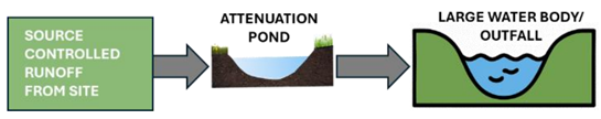
‘The site is predominantly greenfield and relatively large, providing excellent scope to implement an integrated and sustainable stormwater management strategy. Given its size, the area lends itself well to a masterplan-based SuDS design, where runoff from different development parcels can be managed collectively rather than through separate, site-bysite systems. A stormwater attenuation basin could be strategically located along the southern boundary near River Camac if the topography allows. This basin would serve as the main control feature, temporarily storing surface water before releasing it at a restricted rate— kept to the greenfield runoff equivalent or a practical minimum of 2 L/s in accordance with CIRIA guidance. A typical schematic for such site is illustrated below: Additionally, source control SuDS measures such as swales, rain gardens, and permeable paving should be incorporated within individual plots to slow, treat, and retain runoff close to where it falls. These measures will contribute to the overall network, reducing reliance on hard-engineered solutions and enhancing biodiversity and amenity. Exact location of attenuation site will depend on topographical and hydraulic assessment during later design stages.’
And add the following image in the ‘Stormwater Management’ section in A1.1:
Add ‘Stormwater Management’ section in A1.2:
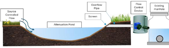
‘Site 2 primarily comprises existing commercial and warehouse developments that are already connected to a stormwater drainage network. In the event of redevelopment or future expansion, it is recommended to incorporate blue/green SuDS measures to improve runoff management, water quality, and site resilience. Suitable measures may include green roofs, tree-pit infiltration, and permeable paving to promote local infiltration and reduce surface runoff. Where sufficient space exists, swales or landscaped attenuation features can be added to enhance on-site storage and reduce peak flows. As a final measure, to minimise pressure on the public drainage network, underground storage tanks may be installed to control discharge at a rate equivalent to the greenfield runoff or 2 L/s, whichever is greater, thereby mitigating the risk of downstream flooding. Site 3 is predominantly greenfield, providing significant flexibility for the implementation of an integrated SuDS strategy within a coordinated masterplan framework. The site’s undeveloped nature allows for a holistic green approach that manages surface water runoff at source, promotes infiltration, and enhances amenity and biodiversity. A stormwater attenuation basin can be strategically located within the site, aligned with the natural topography to collect and temporarily store runoff from surrounding development parcels. The stored water can then be discharged in a controlled manner to the external stormwater network, as illustrated in the schematic below. This controlled release, managed through a flow control chamber ensures that discharge rates do not exceed the greenfield runoff equivalent, or a minimum of 2 L/s, in accordance with CIRIA guidance. The exact location, geometry, and outlet configuration of the basin will be determined following a detailed topographical and drainage connectivity assessment. Where possible, the basin should be integrated with landscaped areas or public open space, creating opportunities for biodiversity enhancement and visual amenity, while contributing to the overall stormwater management capacity.’
And add the following image in the ‘Stormwater Management’ section in A1.2:
Add ‘Stormwater Management’ section in A1.3:
‘At present, Sites 5 and 6 are characterised as compact urban plots, largely occupied by existing buildings. While, Site 4 remains greenfield, offering more flexibility for surface water management interventions. If these three sites are developed collectively under a coordinated masterplan, Site 4 could function as a green infrastructure site. This would allow runoff from Sites 5 and 6 to be conveyed to Site 4, where stormwater attenuation could be achieved. Flow control devices could then regulate discharge to the public stormwater network, ensuring compliance with the greenfield runoff rate or a minimum of 2 L/s, in line with CIRIA SuDS design guidance. However, if the sites are developed individually on a piecemeal basis and Town Centre development is anticipated at these sites. Therefore, limited green opportunities will be available. In this scenario, surface water management should focus on building-integrated SuDS measures, including green roofs, tree infiltration pits, bioretention planters, and permeable paving to promote interception, filtration, and local storage of runoff. Given the limited space, underground storage tanks will be essential to provide adequate attenuation capacity. These tanks should be designed to restrict outflow to the equivalent greenfield runoff rate, preventing surcharging of the downstream public drainage network and reducing the risk of localised flooding.’
Add ‘Stormwater Management’ section in A1.4:
‘Given the anticipated use as Town Centre with high -density redevelopment, the incorporation of surface -based attenuation features such as swales or attenuation ponds may be constrained. Nevertheless, a strong emphasis should be placed on decentralised SuDS measures that can effectively manage runoff close to source. These may include green roofs and podium planting to reduce rainfall impact, tree -pit infiltration systems to promote local infiltration, and permeable paving for car parks or access areas to attenuate flows and improve water quality. Where feasible, landscaped zones or setback areas along the site’s perimeter could accommodate bioretention planters or shallow rain gardens, contributing to both hydraulic control and visual amenity. Nevertheless, underground attenuation storage should be provided to capture excess runoff, with flow -controlled devices before connecting to the existing public stormwater network. Discharge from the site should be limited to the greenfield runoff equivalent or a minimum of 2 L/s, in line with CIRIA guidance.’
|